IMAGES TAKEN NEAR TO
Junction Road, ROBERTSBRIDGE, TN32 5XF
Introduction
This page details the photographs taken nearby to Junction Road, TN32 5XF by members of the Geograph project.
The Geograph project started in 2005 with the aim of publishing, organising and preserving representative images for every square kilometre of Great Britain, Ireland and the Isle of Man.

There are currently over 7.5m images from over14,400 individuals and you can help contribute to the project by visiting https://www.geograph.org.uk
Image Map (Loading...)


Getting Data...Please wait
Leaflet Map data © OpenStreetMap
Images are licensed for reuse under creativecommons.org/licenses/by-sa/2.0
Notes
- Clicking on the map will re-center to the selected point.
- The higher the marker number, the further away the image location is from the centre of the postcode.
Image Listing (14 Images Found)
Images are licensed for reuse under creativecommons.org/licenses/by-sa/2.0
Image
Details
Distance
1
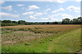
Crop Fields near Park Farm Camping site
Image: © Julian P Guffogg
Taken: 10 Jul 2011
0.11 miles
2
Broad Brook
The name of the field according to Bodiam's 1839 tithe map that is located to the north of the River Rother and west of junction Road, the B2244. Now part of Park Farm Campsite.
Image: © Simon Carey
Taken: 26 Aug 2019
0.15 miles
3

Car on fire, Junction Road near Udiam
The vehicle burst into flames, apparently spontaneously. There was no accident and no one was hurt. Curiously similar to the photo here http://www.geograph.org.uk/photo/1538288
Image: © Patrick Roper
Taken: 31 Jan 2007
0.15 miles
5
Bay Brook
The name of the field according to Ewhurst's 1843 tithe map that is bounded to the west and north by the River Rother, to the east by Junction Road, the B2244, and to the south by the former Kent & East Sussex Light Railway.
Image: © Simon Carey
Taken: 26 Aug 2019
0.22 miles
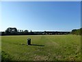
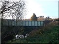
6
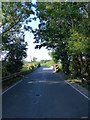
Junction Road
The B2244 crosses the River Rother at Udiam.
Image: © Simon Carey
Taken: 26 Aug 2019
0.23 miles
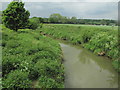
7
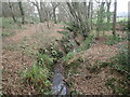
A tributary of the River Rother
This small stream flows into the River Rother about half a mile ahead. The view is from the footbridge seen at https://www.geograph.org.uk/photo/7052090
Image: © Marathon
Taken: 21 Dec 2021
0.23 miles
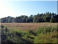
8
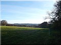
Field near Six Acre Wood
As seen from a footpath towards Salehurst.
A small electric fence has been placed around the edge of the field (but no animals were seen!).
The view looks towards the River Rother valley near Bodiam.
Image: © David Anstiss
Taken: 18 Nov 2012
0.23 miles
9
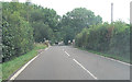
B2244 crosses the River Rother
Just beyond the bridge is the old track-bed of the disused railway.
Image: © Stuart Logan
Taken: 25 Aug 2011
0.24 miles
10
Junction Road bridge over River Rother
As seen from the River Rother footpath from Bodiam.
This carries the B2244 between Hawkhurst and Sedlescombe.
Image: © David Anstiss
Taken: 18 Nov 2012
0.24 miles