IMAGES TAKEN NEAR TO
Junction Road, ROBERTSBRIDGE, TN32 5XB
Introduction
This page details the photographs taken nearby to Junction Road, TN32 5XB by members of the Geograph project.
The Geograph project started in 2005 with the aim of publishing, organising and preserving representative images for every square kilometre of Great Britain, Ireland and the Isle of Man.

There are currently over 7.5m images from over14,400 individuals and you can help contribute to the project by visiting https://www.geograph.org.uk
Image Map (Loading...)


Getting Data...Please wait
Leaflet Map data © OpenStreetMap
Images are licensed for reuse under creativecommons.org/licenses/by-sa/2.0
Notes
- Clicking on the map will re-center to the selected point.
- The higher the marker number, the further away the image location is from the centre of the postcode.
Image Listing (50 Images Found)
Images are licensed for reuse under creativecommons.org/licenses/by-sa/2.0
Image
Details
Distance
1
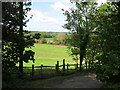
Udiam Cottages
View from the path that leads up from Udiam Farm past the old oasthouses, now a range of business units.
Image: © David M Clark
Taken: 10 May 2023
0.01 miles
2
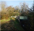
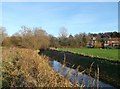
Junction Road bridge over Wellhead Wood Stream (2)
This is the B2244 road leading right towards Cripp's Corner, from Hawkhurst.
It passes over a woodland stream that leads towards the River Rother.
As seen from a footpath beside the stream.
Image: © David Anstiss
Taken: 18 Nov 2012
0.06 miles
3
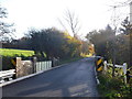
Junction Road bridge over Wellhead Wood Stream
This is the B2244 road leading towards Cripp's Corner.
It passes over a woodland stream that leads towards the River Rother.
Image: © David Anstiss
Taken: 18 Nov 2012
0.07 miles
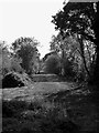
4
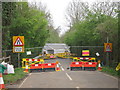
Udiam bridge repairs
Road closed during repairs to a bridge.
Image: © Oast House Archive
Taken: 2 May 2012
0.07 miles
5
Wellhead Wood Stream
As seen from a footpath beside the stream heading from Robertsbridge towards Junction Road.
In the background are the Udiam Cottages beside Junction Road.
Image: © David Anstiss
Taken: 18 Nov 2012
0.08 miles
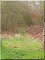
7
Long Brook
The name of the field according to Ewhurst's 1843 tithe map that is located to the south of the dismantled railway and west of Junction Road, the B2244.
Image: © Simon Carey
Taken: 26 Aug 2019
0.10 miles
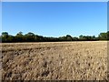
8
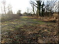
Dismantled Railway
Part of the original Kent & East Sussex Light Railway that opened in 1900 and closed in 1954. Part of the line from Junction Road to Tenterden is now a heritage railway and there are plans to rebuild the section west from Junction Road to Robertsbridge on the national network. The KESR has been purchasing tracts of the line piecemeal over a number of years and has begun to clear the trackbed and rebuild bridges, however, there is local opposition and a public enquiry is due in 2020.
Image: © Simon Carey
Taken: 26 Aug 2019
0.11 miles
9
The future track of the Rother Valley Railway
The current aim is for the Rother Valley Railway to link the Kent & East Sussex Railway at Bodiam to the Rother Valley Railway at Robertsbridge. Work has been going on at both ends. This is the view from Junction Road looking towards Robertsbridge and in the opposite direction from the photograph at https://www.geograph.org.uk/photo/7052119
See http://www.rvr.org.uk/ for more information about the Rother Valley Railway.
Image: © Marathon
Taken: 21 Dec 2021
0.11 miles
10
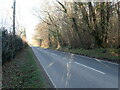
Junction Road
This view looks north from near Compass Park with Crainham Wood on the right. The River Rother is crossed just ahead.
Image: © Marathon
Taken: 21 Dec 2021
0.11 miles