IMAGES TAKEN NEAR TO
Staplecross, ROBERTSBRIDGE, TN32 5QD
Introduction
This page details the photographs taken nearby to TN32 5QD by members of the Geograph project.
The Geograph project started in 2005 with the aim of publishing, organising and preserving representative images for every square kilometre of Great Britain, Ireland and the Isle of Man.

There are currently over 7.5m images from over14,400 individuals and you can help contribute to the project by visiting https://www.geograph.org.uk
Image Map
Images are licensed for reuse under creativecommons.org/licenses/by-sa/2.0
Notes
- Clicking on the map will re-center to the selected point.
- The higher the marker number, the further away the image location is from the centre of the postcode.
Image Listing (129 Images Found)
Images are licensed for reuse under creativecommons.org/licenses/by-sa/2.0
Image
Details
Distance
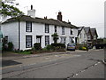
1
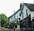
Hill View and School Terrace, Staplecross village
Image: © Patrick Roper
Taken: 5 May 2022
0.00 miles
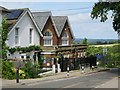
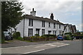
3
Cottages and Staplecross Primary School
Image: © Oast House Archive
Taken: 20 Aug 2017
0.00 miles
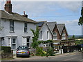
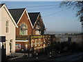
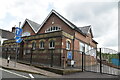
4
Boarded cottages and school, Staplecross
The school is Staplecross Methodist Primary School.
Image: © Robin Webster
Taken: 2 Aug 2012
0.01 miles
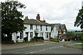
5
School House School Terrace
Grade II listed http://list.historicengland.org.uk/resultsingle.aspx?uid=1233621
Image: © Oast House Archive
Taken: 3 May 2015
0.01 miles
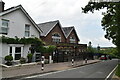
6
Staplecross primary school
A low fog sits on lower ground just behind the school. See Image
Image: © Oast House Archive
Taken: 19 Nov 2010
0.01 miles
10
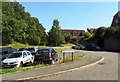
Sheringham Close, Staplecross, East Sussex
Image: © nick macneill
Taken: 7 Sep 2012
0.03 miles