IMAGES TAKEN NEAR TO
Kent Lane, ROBERTSBRIDGE, TN32 5HU
Introduction
This page details the photographs taken nearby to Kent Lane, TN32 5HU by members of the Geograph project.
The Geograph project started in 2005 with the aim of publishing, organising and preserving representative images for every square kilometre of Great Britain, Ireland and the Isle of Man.

There are currently over 7.5m images from over14,400 individuals and you can help contribute to the project by visiting https://www.geograph.org.uk
Image Map
Images are licensed for reuse under creativecommons.org/licenses/by-sa/2.0
Notes
- Clicking on the map will re-center to the selected point.
- The higher the marker number, the further away the image location is from the centre of the postcode.
Image Listing (35 Images Found)
Images are licensed for reuse under creativecommons.org/licenses/by-sa/2.0
Image
Details
Distance
2

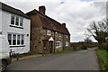
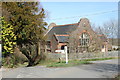
The Old Stores at Hollingrove
Hollingrove is even smaller than the neighbouring village of Brightling. Brightling has The Old School House - see http://www.geograph.org.uk/photo/4043745 and The Old Post Office - see http://www.geograph.org.uk/photo/4043787 while Hollingrove has The Old Chapel and The Old Stores seen here. Both are very isolated and clearly now have not the population to support these.
Image: © Marathon
Taken: 22 Jun 2014
0.01 miles
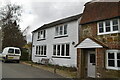
4
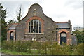
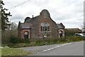
The Chapel House at Hollingrove
The Chapel House is to be found at the only junction of the minor roads that pass through the small hamlet of Hollingrove near Brightling. The relatively modest building has impressive Dutch gable ends and with its symmetrical doorways resembles a village school rather than a Chapel House.
Image: © Nigel Stickells
Taken: 1 Jan 2007
0.01 miles
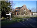
7
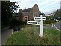
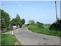
Signpost at Hollingrove
The building opposite is marked as Chapel House on the Ordnance Survey Map but it seemed to be disused at the time I took this photograph.
Image: © Marathon
Taken: 24 Oct 2021
0.03 miles