IMAGES TAKEN NEAR TO
Brightling Road, ROBERTSBRIDGE, TN32 5EH
Introduction
This page details the photographs taken nearby to Brightling Road, TN32 5EH by members of the Geograph project.
The Geograph project started in 2005 with the aim of publishing, organising and preserving representative images for every square kilometre of Great Britain, Ireland and the Isle of Man.

There are currently over 7.5m images from over14,400 individuals and you can help contribute to the project by visiting https://www.geograph.org.uk
Image Map
Images are licensed for reuse under creativecommons.org/licenses/by-sa/2.0
Notes
- Clicking on the map will re-center to the selected point.
- The higher the marker number, the further away the image location is from the centre of the postcode.
Image Listing (33 Images Found)
Images are licensed for reuse under creativecommons.org/licenses/by-sa/2.0
Image
Details
Distance
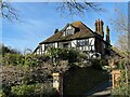
4
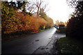
Brightling Road, Robertsbridge, East Sussex
Image: © Oast House Archive
Taken: 3 Dec 2008
0.07 miles
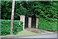
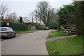
6
The entrance to Darvell Community
http://www.diggersanddreamers.org.uk/index.php?fld=initial&val=D&one=dat&two=det&sel=darvell
Image: © N Chadwick
Taken: 24 Dec 2008
0.09 miles
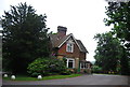
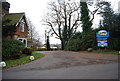
8
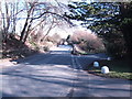
Etchingham Road, Robertsbridge
The lane to the right goes down to Brown's Bridge.
Image: © Jonathan Billinger
Taken: 7 Feb 2007
0.09 miles
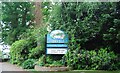
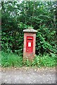
9
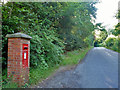
Post box, Brightling Road, Robertsbridge
A George VI box, which I think is number TN32 211.
Image: © Robin Webster
Taken: 2 Aug 2012
0.10 miles