IMAGES TAKEN NEAR TO
Poppinghole Lane, ROBERTSBRIDGE, TN32 5BH
Introduction
This page details the photographs taken nearby to Poppinghole Lane, TN32 5BH by members of the Geograph project.
The Geograph project started in 2005 with the aim of publishing, organising and preserving representative images for every square kilometre of Great Britain, Ireland and the Isle of Man.

There are currently over 7.5m images from over14,400 individuals and you can help contribute to the project by visiting https://www.geograph.org.uk
Image Map
Images are licensed for reuse under creativecommons.org/licenses/by-sa/2.0
Notes
- Clicking on the map will re-center to the selected point.
- The higher the marker number, the further away the image location is from the centre of the postcode.
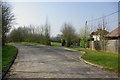
Image Listing (20 Images Found)
Images are licensed for reuse under creativecommons.org/licenses/by-sa/2.0
Image
Details
Distance
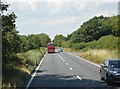
3
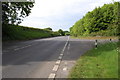
Junction of A21 with Poppinghole Lane
Image: © Julian P Guffogg
Taken: 7 May 2011
0.13 miles
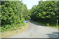
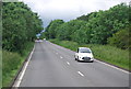
5
Poppinghole Lane near A21
The lane formerly went straight on to the right to meet the A21. It now sweeps round to the left to what is presumably a safer junction point.
Image: © Robin Webster
Taken: 2 Apr 2007
0.13 miles
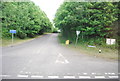
6
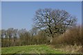
A handsome oak
The hedgerow on the left has a couple of nice oaks. This is one. Birching Wood is ahead.
Image: © Robin Webster
Taken: 2 Apr 2007
0.18 miles