IMAGES TAKEN NEAR TO
Love Lane, RYE, TN31 7NQ
Introduction
This page details the photographs taken nearby to Love Lane, TN31 7NQ by members of the Geograph project.
The Geograph project started in 2005 with the aim of publishing, organising and preserving representative images for every square kilometre of Great Britain, Ireland and the Isle of Man.

There are currently over 7.5m images from over14,400 individuals and you can help contribute to the project by visiting https://www.geograph.org.uk
Image Map
Images are licensed for reuse under creativecommons.org/licenses/by-sa/2.0
Notes
- Clicking on the map will re-center to the selected point.
- The higher the marker number, the further away the image location is from the centre of the postcode.
Image Listing (454 Images Found)
Images are licensed for reuse under creativecommons.org/licenses/by-sa/2.0
Image
Details
Distance
1
Rye College, The Grove, Rye
Built in the first decade of the 20th century as a grammar school which became Thomas Peacock Secondary Modern in 1969. It was converted into an academy about a decade ago.
Image: © Simon Carey
Taken: 27 Jun 2019
0.01 miles
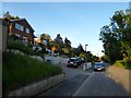
2
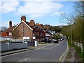
The Grove, Rye
North of the level crossing Rope Walk becomes The Grove, a name it acquired in the early 1900s after the terrace on the left was constructed. Previously it had been a continaution of Rope Walk up to the junction wiuth Deadmans Lane.
Image: © Simon Carey
Taken: 11 Apr 2019
0.08 miles
3
Love Lane, Rye
A cul de sac off The Grove. This is the western end.
Image: © Simon Carey
Taken: 22 Jun 2019
0.08 miles
4
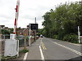
Rye/East Sussex, The Grove
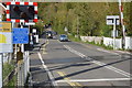
Rye/East Sussex, The Grove, seen from the Marshlink Railway Line level crossing.
Rye is a small town in East Sussex, England, which stands approximately 3 km from the open sea and is at the confluence of three rivers: the Rother, the Tillingham and the Brede.
In medieval times, however, as an important member of the Cinque Ports confederation, it was at the head of an embayment of the English Channel and almost entirely surrounded by the sea.
Rye has a railway station on the "Marshlink" line between Hastings and Ashford.
Image: © Helmut Zozmann
Taken: 27 Jul 2011
0.08 miles
5
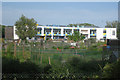
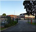
Rye Community Primary School
The colourful arch shaped building is The school and Children's Centre, opened in 2008 and built at a cost of £6m.
Image: © Oast House Archive
Taken: 6 Jun 2010
0.09 miles
6
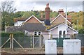
Gate Keeper's Cottage, Rye
Grade II listed. http://www.britishlistedbuildings.co.uk/en-435106-gatekeeper-s-cottage-rye
Image: © N Chadwick
Taken: 21 Sep 2011
0.11 miles
7
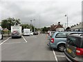
Rye - 2015
Rye, East Sussex, Rye Railway Station carpark
Image: © Helmut Zozmann
Taken: 6 Aug 2015
0.11 miles
8
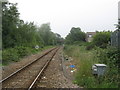
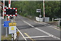
Marshlink line towards Appledore
As seen from Image
This line leads from Hastings, via Rye heading towards Appledore and onwards to Ashford.
In the background is the A268 Road Bridge.
Image: © David Anstiss
Taken: 26 Jun 2011
0.12 miles