IMAGES TAKEN NEAR TO
Fair Meadow, RYE, TN31 7NL
Introduction
This page details the photographs taken nearby to Fair Meadow, TN31 7NL by members of the Geograph project.
The Geograph project started in 2005 with the aim of publishing, organising and preserving representative images for every square kilometre of Great Britain, Ireland and the Isle of Man.

There are currently over 7.5m images from over14,400 individuals and you can help contribute to the project by visiting https://www.geograph.org.uk
Image Map
Images are licensed for reuse under creativecommons.org/licenses/by-sa/2.0
Notes
- Clicking on the map will re-center to the selected point.
- The higher the marker number, the further away the image location is from the centre of the postcode.
Image Listing (47 Images Found)
Images are licensed for reuse under creativecommons.org/licenses/by-sa/2.0
Image
Details
Distance
1
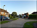
Fair Meadow, Rye
Cul de sac off Rye Hill, the A268 built on the site of a field called Fair Field according to Rye's 1840 tithe map. Built in the 1960s.
Image: © Simon Carey
Taken: 27 Jun 2019
0.01 miles
2
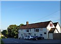
Kings Head Inn, Rye Hill, Rye
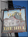
A 17th century coaching inn located on the A268. Was known as the Top 'O The Hill for a while.
Image: © Simon Carey
Taken: 22 Jun 2019
0.08 miles
3
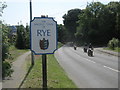
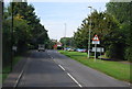
Rye Town sign
On the A268 Rye Hill.
Leading into town from Peasmarsh.
Image: © David Anstiss
Taken: 3 Jul 2011
0.08 miles
4
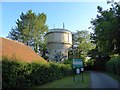
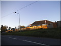
Water Tower, Rye Hill, Rye
Located on the access lane to Rye Cemetery.
Image: © Simon Carey
Taken: 22 Jun 2019
0.08 miles
6

The Top O The Hill
The view of the Pub on the A268.
Image: © Gordon Griffiths
Taken: 22 Nov 2011
0.08 miles
7
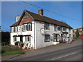
The Top O' The Hill, Rye
Pub on A268 Rye Hill.
Image: © Oast House Archive
Taken: 4 Apr 2011
0.08 miles
10
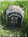
Old Milestone by the A268, Rye Road Hill, Playden
Metal plate attached to stone post by the A268, in parish of PLAYDEN (ROTHER District), Rye Road Hill, opposite Top O' The Hill PH, 25m South of junction with Saltcote Lane, in grass bank between road and path, close to Rye sign, on East side of road. Rye iron plate, erected by the Rye turnpike trust in the 19th century.
Inscription reads:-
LONDON
62
RYE
½
Milestone Society National ID: SX_LR62
Image: © Mike Faherty
Taken: Unknown
0.09 miles