IMAGES TAKEN NEAR TO
Kings Avenue, RYE, TN31 7LX
Introduction
This page details the photographs taken nearby to Kings Avenue, TN31 7LX by members of the Geograph project.
The Geograph project started in 2005 with the aim of publishing, organising and preserving representative images for every square kilometre of Great Britain, Ireland and the Isle of Man.

There are currently over 7.5m images from over14,400 individuals and you can help contribute to the project by visiting https://www.geograph.org.uk
Image Map
Images are licensed for reuse under creativecommons.org/licenses/by-sa/2.0
Notes
- Clicking on the map will re-center to the selected point.
- The higher the marker number, the further away the image location is from the centre of the postcode.
Image Listing (208 Images Found)
Images are licensed for reuse under creativecommons.org/licenses/by-sa/2.0
Image
Details
Distance
1
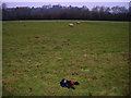
Nobody Loves You When You're Down
Charlton Athletic top discarded in a field of sheep on the footpath that links East Guldeford and Rye. The trees screen the railway line whilst Point Hill can be seen in the background.
Image: © Simon Carey
Taken: 28 Dec 2006
0.02 miles
2
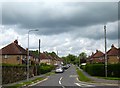
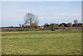
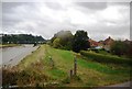
Kings Avenue, Rye
Housing estate built in the 1930s on the eastern side of the River Rother.
Image: © Simon Carey
Taken: 10 May 2019
0.04 miles
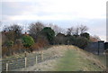
4
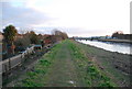
The Sussex Border Path along the Rother goes under the Marsh Line
Image: © N Chadwick
Taken: 6 Mar 2010
0.07 miles
8
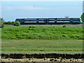
Train on an Eastbourne - Ashford service
A class 171/7 unit accelerates away from Rye.
Image: © Robin Webster
Taken: 29 May 2014
0.08 miles
9
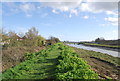
Sussex Border Path along the River Rother
Image: © N Chadwick
Taken: 16 Sep 2009
0.09 miles
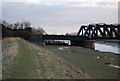
10
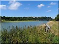
The River Rother from the east bank
Railway bridge visible in the distance.
Image: © Bikeboy
Taken: 24 Jul 2013
0.09 miles