IMAGES TAKEN NEAR TO
Ludley Hill, RYE, TN31 6XP
Introduction
This page details the photographs taken nearby to Ludley Hill, TN31 6XP by members of the Geograph project.
The Geograph project started in 2005 with the aim of publishing, organising and preserving representative images for every square kilometre of Great Britain, Ireland and the Isle of Man.

There are currently over 7.5m images from over14,400 individuals and you can help contribute to the project by visiting https://www.geograph.org.uk
Image Map
Images are licensed for reuse under creativecommons.org/licenses/by-sa/2.0
Notes
- Clicking on the map will re-center to the selected point.
- The higher the marker number, the further away the image location is from the centre of the postcode.
Image Listing (17 Images Found)
Images are licensed for reuse under creativecommons.org/licenses/by-sa/2.0
Image
Details
Distance
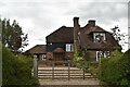
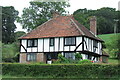
1
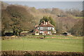
Ludley Farm House Beckley East Sussex
Picturesque Farm House on the road from Beckley Wood to the B2089 Broad Oak, Udimore Road.
Image: © Janet Richardson
Taken: 6 Mar 2006
0.01 miles
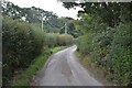
2
Ludley Farm
Some distance from Beckley village.
Image: © David M Clark
Taken: 9 Jul 2019
0.01 miles
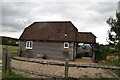
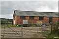
3
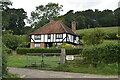
Ludley Farmhouse
Grade II listed' https://historicengland.org.uk/listing/the-list/list-entry/1278263
Image: © N Chadwick
Taken: 11 Sep 2020
0.02 miles