IMAGES TAKEN NEAR TO
Starvecrow Lane, RYE, TN31 6XL
Introduction
This page details the photographs taken nearby to Starvecrow Lane, TN31 6XL by members of the Geograph project.
The Geograph project started in 2005 with the aim of publishing, organising and preserving representative images for every square kilometre of Great Britain, Ireland and the Isle of Man.

There are currently over 7.5m images from over14,400 individuals and you can help contribute to the project by visiting https://www.geograph.org.uk
Image Map (Loading...)


Getting Data...Please wait
Leaflet Map data © OpenStreetMap
Images are licensed for reuse under creativecommons.org/licenses/by-sa/2.0
Notes
- Clicking on the map will re-center to the selected point.
- The higher the marker number, the further away the image location is from the centre of the postcode.
Image Listing (6 Images Found)
Images are licensed for reuse under creativecommons.org/licenses/by-sa/2.0
Image
Details
Distance

2
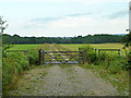
Private track to Pelsham
A recent creation, as it does not appear on maps. It is hard to see its point, as it duplicates the entirely adequate tarmac surfaced old route.
Image: © Robin Webster
Taken: 13 Jul 2014
0.11 miles
3
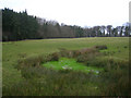
Morebread Wood
Boggy ground and pasture opposite Button's Farmhouse.
Image: © Simon Carey
Taken: 10 Feb 2007
0.21 miles
5
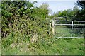
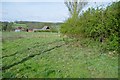
Stile obstructed by vegetation
Public footpath Peasmarsh 29 to Starvecrow Lane.
Image: © Peter Holmes
Taken: 30 Apr 2010
0.23 miles
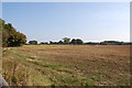
6
Footpath to Barline Farm
Public footpath Peasmarsh 29 to Starvecrow Lane.
Image: © Peter Holmes
Taken: 30 Apr 2010
0.24 miles