IMAGES TAKEN NEAR TO
Stoddards Lane, RYE, TN31 6UG
Introduction
This page details the photographs taken nearby to Stoddards Lane, TN31 6UG by members of the Geograph project.
The Geograph project started in 2005 with the aim of publishing, organising and preserving representative images for every square kilometre of Great Britain, Ireland and the Isle of Man.

There are currently over 7.5m images from over14,400 individuals and you can help contribute to the project by visiting https://www.geograph.org.uk
Image Map (Loading...)


Getting Data...Please wait
Leaflet Map data © OpenStreetMap
Images are licensed for reuse under creativecommons.org/licenses/by-sa/2.0
Notes
- Clicking on the map will re-center to the selected point.
- The higher the marker number, the further away the image location is from the centre of the postcode.
Image Listing (17 Images Found)
Images are licensed for reuse under creativecommons.org/licenses/by-sa/2.0
Image
Details
Distance
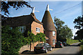
3
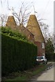
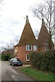
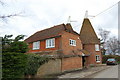
Oast House in Stoddards Lane
Oast Houses converted to private dwellings close to Stoddards Farm between Beckley and Northiam.
Image: © Tim Knight
Taken: 5 Mar 2007
0.07 miles
8
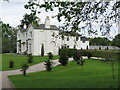
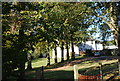
Old Rectory at Beckley
One of several very substantial mansions in this corner of Beckley. It was built for the rector in 1636, but substantially remodelled in 1839.
Image: © David M Clark
Taken: 11 May 2023
0.21 miles