IMAGES TAKEN NEAR TO
Kitchenour Lane, RYE, TN31 6TF
Introduction
This page details the photographs taken nearby to Kitchenour Lane, TN31 6TF by members of the Geograph project.
The Geograph project started in 2005 with the aim of publishing, organising and preserving representative images for every square kilometre of Great Britain, Ireland and the Isle of Man.

There are currently over 7.5m images from over14,400 individuals and you can help contribute to the project by visiting https://www.geograph.org.uk
Image Map
Images are licensed for reuse under creativecommons.org/licenses/by-sa/2.0
Notes
- Clicking on the map will re-center to the selected point.
- The higher the marker number, the further away the image location is from the centre of the postcode.
Image Listing (21 Images Found)
Images are licensed for reuse under creativecommons.org/licenses/by-sa/2.0
Image
Details
Distance
1
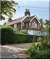
Little Shepherds, Kitchenour Lane
Quite a big house, in a wooded setting near the entrance to Shepherds Farm. There is an extension to the west that appears to be quite recent - with similar tile-hanging, but much simpler, more box-like.
I find it very hard to guess at the age of the house - the Gothicky windows might suggest circa 1820, but the barge-boards (with their pinnacles) look later (what I might call Railway Age). No close parallels come to mind, but I'm vaguely reminded of a house in Berkshire: Image
Image: © Stefan Czapski
Taken: 9 Sep 2017
0.03 miles
2
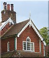
Little Shepherds, Kitchenour Lane: tile-hanging and barge-boards
Whoever designed this house plainly had a lot of fun doing so. The three-light window under the gable is a fanciful Gothick variation on what (in classical architectural terms) would be known as a Venetian window.
I rather wonder when the house was built - my web-search yielded no information. The barge-boards with their (signal-box style) pinnacles look 'Railway Age', whereas the Gothick touches are typical of - say - 1820. But I wouldn't rule out a date in the 1890s.
Image: © Stefan Czapski
Taken: 9 Sep 2017
0.03 miles
4
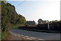
Mackerel Hill near Beckley, East Sussex
Image: © Oast House Archive
Taken: 18 Sep 2008
0.15 miles
5
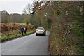
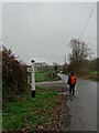
High Weald Landscape Trail near to Decoy Pond
Image: © Peter S
Taken: 15 Sep 2012
0.15 miles
8

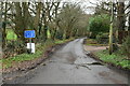
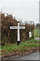
Old Direction Sign - Signpost by Mackerel Hill, Peasmarsh parish
Black iron cap finial - 3 arms; East Sussex wood by the UC road, in parish of Peasmarsh (Rother District), on verge opposite junction of Kitchenour Lane with Mackerel Hill.
Surveyed
Milestone Society National ID: SX_TQ8724
Image: © Milestone Society
Taken: Unknown
0.16 miles
9
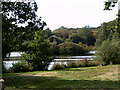
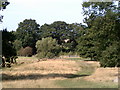
Glimpse of Decoy Pond
Decoy Pond lies just off the High Weald Landscape Trail to the north of Streamland Wood.
Image: © Peter S
Taken: 15 Sep 2012
0.18 miles