IMAGES TAKEN NEAR TO
Main Street, RYE, TN31 6SS
Introduction
This page details the photographs taken nearby to Main Street, TN31 6SS by members of the Geograph project.
The Geograph project started in 2005 with the aim of publishing, organising and preserving representative images for every square kilometre of Great Britain, Ireland and the Isle of Man.

There are currently over 7.5m images from over14,400 individuals and you can help contribute to the project by visiting https://www.geograph.org.uk
Image Map (Loading...)


Getting Data...Please wait
Leaflet Map data © OpenStreetMap
Images are licensed for reuse under creativecommons.org/licenses/by-sa/2.0
Notes
- Clicking on the map will re-center to the selected point.
- The higher the marker number, the further away the image location is from the centre of the postcode.
Image Listing (60 Images Found)
Images are licensed for reuse under creativecommons.org/licenses/by-sa/2.0
Image
Details
Distance
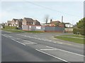
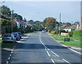
1
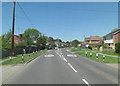
Main Street
The turning for the Recreation Ground is coming up on the right.
Image: © Stuart Logan
Taken: 26 May 2012
0.01 miles
2
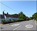
White Knights, Main Street, Peasmarsh
A row of three cottages dating back to the early 19th century.
Image: © Simon Carey
Taken: 27 Jun 2019
0.02 miles
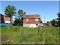
5
Land adjacent to Oast Cottage, Main Street
Planning permission has been approved by Rother District Council under application number RR/2010/925/P for the “erection of detached 2-storey house with associated access from Main Street and carport ancillary to the existing house”. It appears that the new house is to called Hamish Court, as this is the name that appears on the hoarding. Oast Cottage can be seen peeping over the hoarding to the left of the pole.
Image: © John Baker
Taken: 23 Feb 2014
0.03 miles
6
Oast Cottage, Main Street, Peasmarsh
Located on the corner of Main Street and The Maltings and currently undergoing major renovation work.
Image: © Simon Carey
Taken: 27 Jun 2019
0.03 miles
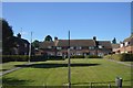
7
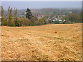
Looking Down on Peasmarsh
Taken from the footpath to Vansghyll House looking down on the village nestled between the rises in ground.
Image: © Simon Carey
Taken: 13 Apr 2007
0.04 miles
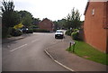
8
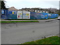
Building site, The Maltings
Planning permission has been approved, with conditions, by Rother District Council under application number RR/2016/4/P for the “demolition and redevelopment of The Maltings and bungalows to provide 12 x 2 bed houses, 4 x 3 bed houses and 1 x 2 bed bungalow and 19 x 1 bed units for older persons (HOPS) with associated parking, bin and refuse”.
Image: © John Baker
Taken: 19 Mar 2017
0.06 miles
10

Former shop, Main Street, Peasmarsh
This was once a Spar supermarket. The word 'Spar' can just be made out over the door.
Image: © John Baker
Taken: 8 Jul 2012
0.06 miles