IMAGES TAKEN NEAR TO
Horseshoe Lane, RYE, TN31 6SD
Introduction
This page details the photographs taken nearby to Horseshoe Lane, TN31 6SD by members of the Geograph project.
The Geograph project started in 2005 with the aim of publishing, organising and preserving representative images for every square kilometre of Great Britain, Ireland and the Isle of Man.

There are currently over 7.5m images from over14,400 individuals and you can help contribute to the project by visiting https://www.geograph.org.uk
Image Map
Images are licensed for reuse under creativecommons.org/licenses/by-sa/2.0
Notes
- Clicking on the map will re-center to the selected point.
- The higher the marker number, the further away the image location is from the centre of the postcode.
Image Listing (11 Images Found)
Images are licensed for reuse under creativecommons.org/licenses/by-sa/2.0
Image
Details
Distance
5
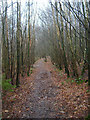
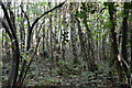
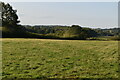
Footpath through Milldown Wood
Linking Horseshoe Lane with King's Barn Lane. Birches are the predominant tree here.
Image: © Simon Carey
Taken: 10 Feb 2007
0.22 miles
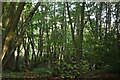
6
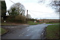
Crossroads of Furnace, Horseshoe and Kings Bank lanes
Image: © Julian P Guffogg
Taken: 28 Mar 2010
0.23 miles
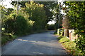
7
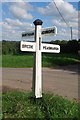
Old Direction Sign - Signpost by Furnace Lane,
Black iron cap finial - 4 arms; East Sussex wood by the UC road, in parish of Beckley (Rother District), on verge at crossroads formed by intersection of Furnace Lane and Kings Bank Lane with Horseshoe Lane.
Surveyed
Milestone Society National ID: SX_TQ8422
Image: © Milestone Society
Taken: Unknown
0.23 miles
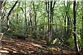
10
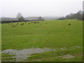
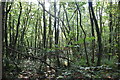
Dreary Day, South of Beckley
Taken from the footpath that links Clayhill with Horseshoe Lane. The woodland in the distance is Hoath Wood whilst the fields in the foreground are waterlogged from the previous week's snow and last night's downpour. In fact it was still lightly raining at this point.
Image: © Simon Carey
Taken: 10 Feb 2007
0.24 miles