IMAGES TAKEN NEAR TO
Kings Bank Lane, RYE, TN31 6RT
Introduction
This page details the photographs taken nearby to Kings Bank Lane, TN31 6RT by members of the Geograph project.
The Geograph project started in 2005 with the aim of publishing, organising and preserving representative images for every square kilometre of Great Britain, Ireland and the Isle of Man.

There are currently over 7.5m images from over14,400 individuals and you can help contribute to the project by visiting https://www.geograph.org.uk
Image Map
Images are licensed for reuse under creativecommons.org/licenses/by-sa/2.0
Notes
- Clicking on the map will re-center to the selected point.
- The higher the marker number, the further away the image location is from the centre of the postcode.
Image Listing (25 Images Found)
Images are licensed for reuse under creativecommons.org/licenses/by-sa/2.0
Image
Details
Distance
2
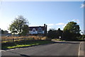
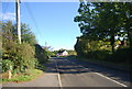
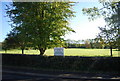
Beckley playing field
Looking at houses in Main Street.
Image: © colin bryant
Taken: 12 May 2008
0.05 miles

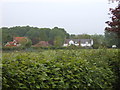
5
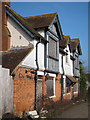
Royal Oak, Beckley
Closed pub at Kings Bank Lane and Mains Street junction. The pub has been closed a number of years and will most likely end up converted if not demolished to make way for a number of houses.
Image: © Oast House Archive
Taken: 22 Mar 2011
0.06 miles
6
The Royal Oak, Beckley
Closed pub at Kings Bank Lane and Mains Street junction. The pub has been closed a number of years and will most likely end up converted if not demolished to make way for a number of houses.
Image: © Oast House Archive
Taken: 22 Mar 2011
0.06 miles
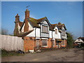
7
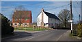
New houses on site of former Royal Oak
New houses at junction with King's Bank Lane.
See former pub Image
Image: © Oast House Archive
Taken: 15 Mar 2014
0.07 miles
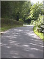
10
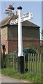
Direction Sign - Signpost by the B2088, Beckley
Black iron cap finial - 3 arms; East Sussex wood with number by the B2088, in parish of Beckley (Rother District), Beckley, opposite junction with UC road to Broad Oak.
Surveyed
Milestone Society National ID: SX_TQ8524
Image: © Milestone Society
Taken: Unknown
0.11 miles