IMAGES TAKEN NEAR TO
Ghyllside Road, RYE, TN31 6QG
Introduction
This page details the photographs taken nearby to Ghyllside Road, TN31 6QG by members of the Geograph project.
The Geograph project started in 2005 with the aim of publishing, organising and preserving representative images for every square kilometre of Great Britain, Ireland and the Isle of Man.

There are currently over 7.5m images from over14,400 individuals and you can help contribute to the project by visiting https://www.geograph.org.uk
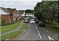
Image Map
Images are licensed for reuse under creativecommons.org/licenses/by-sa/2.0
Notes
- Clicking on the map will re-center to the selected point.
- The higher the marker number, the further away the image location is from the centre of the postcode.
Image Listing (20 Images Found)
Images are licensed for reuse under creativecommons.org/licenses/by-sa/2.0
Image
Details
Distance
3
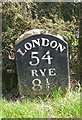
Old Milestone by the A28, Station Road, Northiam
Metal plate attached to stone post by the A28, in parish of Northiam (Rother District), Station Road; opposite the junction with Monks Way in front of Rosina, on the verge, on East side of road. Rye iron plate, erected by the Rye turnpike trust in the 19th century.
Inscription reads:-
LONDON
54
RYE
8½
Rivet benchmark on top.
Milestone Society National ID: SX_LR54
Image: © M Faherty
Taken: 11 May 2008
0.11 miles
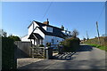
7
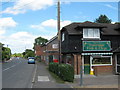
Northiam Fish Bar
On the A28 Station Road.
Image: © David Anstiss
Taken: 7 Jun 2011
0.16 miles