IMAGES TAKEN NEAR TO
Main Street, RYE, TN31 6LP
Introduction
This page details the photographs taken nearby to Main Street, TN31 6LP by members of the Geograph project.
The Geograph project started in 2005 with the aim of publishing, organising and preserving representative images for every square kilometre of Great Britain, Ireland and the Isle of Man.

There are currently over 7.5m images from over14,400 individuals and you can help contribute to the project by visiting https://www.geograph.org.uk
Image Map
Images are licensed for reuse under creativecommons.org/licenses/by-sa/2.0
Notes
- Clicking on the map will re-center to the selected point.
- The higher the marker number, the further away the image location is from the centre of the postcode.
Image Listing (99 Images Found)
Images are licensed for reuse under creativecommons.org/licenses/by-sa/2.0
Image
Details
Distance
1
![Northiam buildings [10]](https://s2.geograph.org.uk/geophotos/07/24/10/7241066_464266fe_120x120.jpg)
Northiam buildings [10]
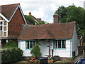
This house named Foxes is an 18th century addition to a 17th century building in Main Street. The 17th century part houses Hairtique, a hairdressing establishment, and Warwick House (seen at Image). Constructed of brick, faced with weatherboard, under tile roofs. Listed, grade II, with details at: https://historicengland.org.uk/listing/the-list/list-entry/1217021
Northiam is a large village in the valley of the River Rother, East Sussex, some 10 miles north of Hastings. The village sits astride the A28 road from Canterbury to Hastings. Queen Elizabeth I stopped in the village for a meal and left behind a pair of green damask shoes. In May 1944, just before D Day, the Prime Ministers of four countries inspected the troops of Southern Command on the village playing fields. Great Dixter House and gardens form the western edge of the village.
Image: © Michael Dibb
Taken: 10 May 2022
0.00 miles
2
![Northiam buildings [9]](https://s3.geograph.org.uk/geophotos/07/24/10/7241063_776fd654_120x120.jpg)
Northiam buildings [9]
This 17th century building in Main Street, houses Hairtique, a hairdressing establishment, and Warwick House. An 18th century addition is a house named Foxes (seen at Image). Constructed of brick, faced with weatherboard, under tile roofs. Listed, grade II, with details at: https://historicengland.org.uk/listing/the-list/list-entry/1217021
Northiam is a large village in the valley of the River Rother, East Sussex, some 10 miles north of Hastings. The village sits astride the A28 road from Canterbury to Hastings. Queen Elizabeth I stopped in the village for a meal and left behind a pair of green damask shoes. In May 1944, just before D Day, the Prime Ministers of four countries inspected the troops of Southern Command on the village playing fields. Great Dixter House and gardens form the western edge of the village.
Image: © Michael Dibb
Taken: 10 May 2022
0.00 miles
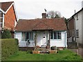
3
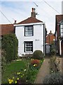
Winders, Northiam
A small timber panelled cottage on the A28 Main Road in Northiam.
Image: © David Anstiss
Taken: 7 Jun 2011
0.01 miles
6
Library sign
In the village of Northiam, see http://www.eastsussex.gov.uk/libraries/find/northiam/default.htm .
Image: © Barbara Carr
Taken: 23 Sep 2010
0.02 miles
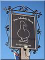
8
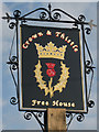
![Northiam buildings [7]](https://s0.geograph.org.uk/geophotos/07/24/10/7241056_7c273479_120x120.jpg)
Northiam buildings [7]
This public house in Main Street is now closed and boarded-up. Formerly the Crown and Thistle Inn, it closed for refurbishment in 2009 and reopened as The Muddy Duck in 2011 and closed again in 2018. The building is 17th century, or. possibly, earlier, timber framed, faced with weatherboard with both gables jettied. The ground floor was built out in the 20th century. All under a tile roof. Listed, grade II, with details at: https://historicengland.org.uk/listing/the-list/list-entry/1275682
Northiam is a large village in the valley of the River Rother, East Sussex, some 10 miles north of Hastings. The village sits astride the A28 road from Canterbury to Hastings. Queen Elizabeth I stopped in the village for a meal and left behind a pair of green damask shoes. In May 1944, just before D Day, the Prime Ministers of four countries inspected the troops of Southern Command on the village playing fields. Great Dixter House and gardens form the western edge of the village.
Image: © Michael Dibb
Taken: 10 May 2022
0.02 miles
10
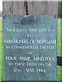
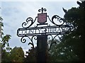
Plaque on Commemorative Gates, Northiam
Image: © Barbara Carr
Taken: 23 Sep 2010
0.02 miles