IMAGES TAKEN NEAR TO
Horns Cross, RYE, TN31 6JE
Introduction
This page details the photographs taken nearby to Horns Cross, TN31 6JE by members of the Geograph project.
The Geograph project started in 2005 with the aim of publishing, organising and preserving representative images for every square kilometre of Great Britain, Ireland and the Isle of Man.

There are currently over 7.5m images from over14,400 individuals and you can help contribute to the project by visiting https://www.geograph.org.uk
Image Map
Images are licensed for reuse under creativecommons.org/licenses/by-sa/2.0
Notes
- Clicking on the map will re-center to the selected point.
- The higher the marker number, the further away the image location is from the centre of the postcode.
Image Listing (15 Images Found)
Images are licensed for reuse under creativecommons.org/licenses/by-sa/2.0
Image
Details
Distance
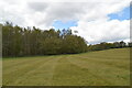
2
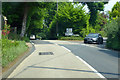
Junction, Horns Cross
The B2145 veers right off the A28.
Image: © Robin Webster
Taken: 23 May 2018
0.08 miles
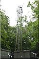
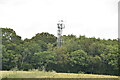
10

Telecommunications station in Commons Wood
Seen from the footpath leading north to Mill Corner.
Image: © David M Clark
Taken: 26 Feb 2019
0.23 miles