IMAGES TAKEN NEAR TO
Sherbourne Place, RYE, TN31 6DE
Introduction
This page details the photographs taken nearby to Sherbourne Place, TN31 6DE by members of the Geograph project.
The Geograph project started in 2005 with the aim of publishing, organising and preserving representative images for every square kilometre of Great Britain, Ireland and the Isle of Man.

There are currently over 7.5m images from over14,400 individuals and you can help contribute to the project by visiting https://www.geograph.org.uk
Image Map
Images are licensed for reuse under creativecommons.org/licenses/by-sa/2.0
Notes
- Clicking on the map will re-center to the selected point.
- The higher the marker number, the further away the image location is from the centre of the postcode.
Image Listing (14 Images Found)
Images are licensed for reuse under creativecommons.org/licenses/by-sa/2.0
Image
Details
Distance
3
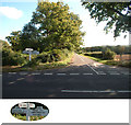
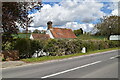
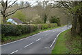
A28 south of Northiam, East Sussex TN31
Junction with New Road, looking east.
Image: © Philip Talmage
Taken: 2 Oct 2005
0.08 miles
5
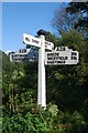
Old Direction Sign - Signpost by the A28, Hastings Road, Northiam
Black iron cap finial - 3 arms; East Sussex wood with number by the A28, in parish of Northiam (Rother District), Hastings Road, on verge at corner of intersection where New Road crosses the A28.
Surveyed
Milestone Society National ID: SX_TQ8223A
Image: © Milestone Society
Taken: Unknown
0.10 miles
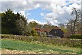
10
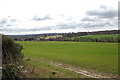
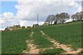
Sherbourne Valley near Mill Corner
Image: © Julian P Guffogg
Taken: 28 Mar 2010
0.20 miles