IMAGES TAKEN NEAR TO
St. Marys Lane, TUNBRIDGE WELLS, TN3 0PR
Introduction
This page details the photographs taken nearby to St. Marys Lane, TN3 0PR by members of the Geograph project.
The Geograph project started in 2005 with the aim of publishing, organising and preserving representative images for every square kilometre of Great Britain, Ireland and the Isle of Man.

There are currently over 7.5m images from over14,400 individuals and you can help contribute to the project by visiting https://www.geograph.org.uk
Image Map
Images are licensed for reuse under creativecommons.org/licenses/by-sa/2.0
Notes
- Clicking on the map will re-center to the selected point.
- The higher the marker number, the further away the image location is from the centre of the postcode.
Image Listing (280 Images Found)
Images are licensed for reuse under creativecommons.org/licenses/by-sa/2.0
Image
Details
Distance
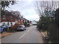
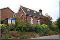
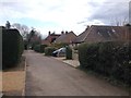
1
Speldhurst Village Hall
At the end of St. Mary's Lane. Beyond is a recreational ground.
Image: © David Anstiss
Taken: 7 Jun 2010
0.03 miles
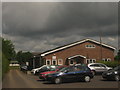
5
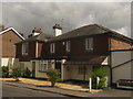
Northfield House
Converted pub at the junction of Northfields and Penshurst Road.
Image: © David Anstiss
Taken: 7 Jun 2010
0.06 miles
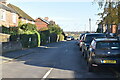
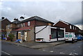
6
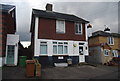
The Old Bakery, Speldhurst
Converted to a house.
Image: © N Chadwick
Taken: 26 Feb 2011
0.06 miles
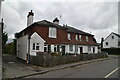
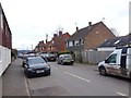
9
Former pub, Speldhurst
The Northfield, converted to a private residence.
Image: © N Chadwick
Taken: 26 Feb 2011
0.07 miles