IMAGES TAKEN NEAR TO
Wittersham, TENTERDEN, TN30 7PT
Introduction
This page details the photographs taken nearby to TN30 7PT by members of the Geograph project.
The Geograph project started in 2005 with the aim of publishing, organising and preserving representative images for every square kilometre of Great Britain, Ireland and the Isle of Man.

There are currently over 7.5m images from over14,400 individuals and you can help contribute to the project by visiting https://www.geograph.org.uk
Image Map
Images are licensed for reuse under creativecommons.org/licenses/by-sa/2.0
Notes
- Clicking on the map will re-center to the selected point.
- The higher the marker number, the further away the image location is from the centre of the postcode.
Image Listing (5 Images Found)
Images are licensed for reuse under creativecommons.org/licenses/by-sa/2.0
Image
Details
Distance
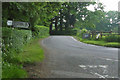
3
Swan Street
Or at least it was called that further back nearer Wittersham.
Image: © Robin Webster
Taken: 23 May 2018
0.08 miles
4
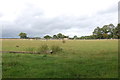
Wittersham Levels
This is the Oxney side of the Rother, looking up a small valley towards Valley Farm.
Image: © Simon Carey
Taken: 13 Apr 2007
0.16 miles
5
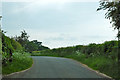
Wittersham Road at junction for Moons Green
There is a sign ahead warning of a duck and ducklings, almost certainly privately erected judging by its position.
Image: © Robin Webster
Taken: 23 May 2018
0.23 miles