IMAGES TAKEN NEAR TO
Smallhythe Road, TENTERDEN, TN30 7LR
Introduction
This page details the photographs taken nearby to Smallhythe Road, TN30 7LR by members of the Geograph project.
The Geograph project started in 2005 with the aim of publishing, organising and preserving representative images for every square kilometre of Great Britain, Ireland and the Isle of Man.

There are currently over 7.5m images from over14,400 individuals and you can help contribute to the project by visiting https://www.geograph.org.uk
Image Map (Loading...)


Getting Data...Please wait
Leaflet Map data © OpenStreetMap
Images are licensed for reuse under creativecommons.org/licenses/by-sa/2.0
Notes
- Clicking on the map will re-center to the selected point.
- The higher the marker number, the further away the image location is from the centre of the postcode.
Image Listing (25 Images Found)
Images are licensed for reuse under creativecommons.org/licenses/by-sa/2.0
Image
Details
Distance
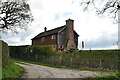
2
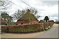
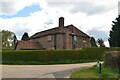
The Dutch House, The Quarter
Part of the Morghew Estate. Built in C.1425. Seen from a 'road used as a public path' leading from Small Hythe Road to Heronden.
Image: © David Anstiss
Taken: 7 Mar 2010
0.02 miles
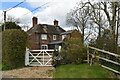
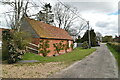
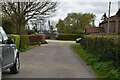
7
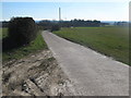
Farm Road to Morghew Farm
This farm road leads from The Quarter within the Morghew Estate. The road is also a public path to the farm. In the background is Nine Acre Wood.
Image: © David Anstiss
Taken: 7 Mar 2010
0.06 miles
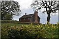
8
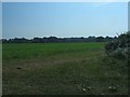
Crop fields
The fields in the north west corner of this square
Image: © Barry Hunter
Taken: 4 Sep 2005
0.09 miles