IMAGES TAKEN NEAR TO
Stone, TENTERDEN, TN30 7JN
Introduction
This page details the photographs taken nearby to TN30 7JN by members of the Geograph project.
The Geograph project started in 2005 with the aim of publishing, organising and preserving representative images for every square kilometre of Great Britain, Ireland and the Isle of Man.

There are currently over 7.5m images from over14,400 individuals and you can help contribute to the project by visiting https://www.geograph.org.uk
Image Map (Loading...)


Getting Data...Please wait
Leaflet Map data © OpenStreetMap
Images are licensed for reuse under creativecommons.org/licenses/by-sa/2.0
Notes
- Clicking on the map will re-center to the selected point.
- The higher the marker number, the further away the image location is from the centre of the postcode.
Image Listing (35 Images Found)
Images are licensed for reuse under creativecommons.org/licenses/by-sa/2.0
Image
Details
Distance

10
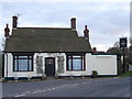
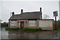
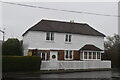
Crown Inn
at the junction of The Street, Catt's Hill and Church Hill. Looks like a private house but still open as a pub.
Image: © Roger W Haworth
Taken: 21 Mar 2007
0.05 miles