IMAGES TAKEN NEAR TO
Stone, TENTERDEN, TN30 7JH
Introduction
This page details the photographs taken nearby to TN30 7JH by members of the Geograph project.
The Geograph project started in 2005 with the aim of publishing, organising and preserving representative images for every square kilometre of Great Britain, Ireland and the Isle of Man.

There are currently over 7.5m images from over14,400 individuals and you can help contribute to the project by visiting https://www.geograph.org.uk
Image Map (Loading...)


Getting Data...Please wait
Leaflet Map data © OpenStreetMap
Images are licensed for reuse under creativecommons.org/licenses/by-sa/2.0
Notes
- Clicking on the map will re-center to the selected point.
- The higher the marker number, the further away the image location is from the centre of the postcode.
Image Listing (12 Images Found)
Images are licensed for reuse under creativecommons.org/licenses/by-sa/2.0
Image
Details
Distance

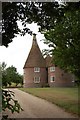
2
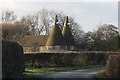
Odiam Oast, Lower Road, Stone In Oxney
Image: © Oast House Archive
Taken: 3 Dec 2011
0.05 miles
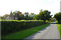

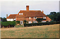
7
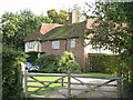
Cherry Farmhouse, Stone Cum Ebony
Grade II listed timber framed C16 house.
Image: © Oast House Archive
Taken: 5 Oct 2007
0.15 miles
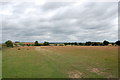
8
Sheep grazing in fields near Odiam Farm on the Isle of Oxney
Image: © Jacqui Sadler
Taken: 25 Apr 2007
0.16 miles
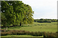
10
View over Odiam Farm
As seen from a footpath from Wittersham Road to Lower Road.
Image: © David Anstiss
Taken: 1 Aug 2010
0.22 miles