IMAGES TAKEN NEAR TO
Stone, TENTERDEN, TN30 7HG
Introduction
This page details the photographs taken nearby to TN30 7HG by members of the Geograph project.
The Geograph project started in 2005 with the aim of publishing, organising and preserving representative images for every square kilometre of Great Britain, Ireland and the Isle of Man.

There are currently over 7.5m images from over14,400 individuals and you can help contribute to the project by visiting https://www.geograph.org.uk
Image Map (Loading...)


Getting Data...Please wait
Leaflet Map data © OpenStreetMap
Images are licensed for reuse under creativecommons.org/licenses/by-sa/2.0
Notes
- Clicking on the map will re-center to the selected point.
- The higher the marker number, the further away the image location is from the centre of the postcode.
Image Listing (20 Images Found)
Images are licensed for reuse under creativecommons.org/licenses/by-sa/2.0
Image
Details
Distance
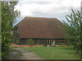
4
Stocks Mill, Wittersham Isle of Oxney, Kent
The Isle of Oxney was once an island in medieval times, a high spot surrounded by sea and marsh. On top of the island is Stocks Mill, a post mill with a roundhouse of tarred brick under a sloping wooden felted roof. It is the tallest of the county’s remaining post mills. The centre post of the mill has the date 1781 and the initials RV carved on it - this is either the date of the mill’s construction or the date it was moved to Wittersham. (Information from Kent County Council who now own the mill.)
Image: © Ron Strutt
Taken: 29 Jun 2004
0.10 miles
5
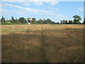
Footpath to The Stocks
This path leads from Acton Lane via Stemps Wood and this horse paddock towards Stocks Road.
In the background is Stocks Water Tower and Stocks Farm Oast House.
Image: © David Anstiss
Taken: 1 Aug 2010
0.12 miles
6
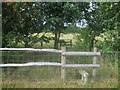
Two stiles and two hedges near Maynes Farm
A footpath from Lower Road, passes Odiam Farm and then Maynes Farm on Wittersham Road.
Image: © David Anstiss
Taken: 1 Aug 2010
0.15 miles
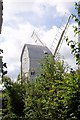
7
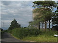
Water Tower at The Stocks
At the junction of Rose Hill (on the left) and Wittersham Road (on the right).
Feeds the houses of Wittersham on the Isle of Oxney.
Image: © David Anstiss
Taken: 1 Aug 2010
0.16 miles
8
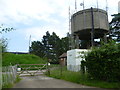
Water Tower at The Stocks
Seen across Rose Hill, the water tower has a small covered reservoir behind which can be seen to the left.
Image: © Marathon
Taken: 23 Jun 2014
0.16 miles
9
Maynes Farm (2)
Converted Barn farmhouse near Wittersham Road.
As seen from footpath from Lower Road, past Odiam Farm towards Wittersham.
Image: © David Anstiss
Taken: 1 Aug 2010
0.18 miles
10
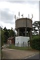
Water Tower, Rose Hill, Wittersham
Complete with numerous communications antennae.
Image: © Julian P Guffogg
Taken: 25 Jul 2010
0.18 miles