IMAGES TAKEN NEAR TO
Wittersham, TENTERDEN, TN30 7EP
Introduction
This page details the photographs taken nearby to TN30 7EP by members of the Geograph project.
The Geograph project started in 2005 with the aim of publishing, organising and preserving representative images for every square kilometre of Great Britain, Ireland and the Isle of Man.

There are currently over 7.5m images from over14,400 individuals and you can help contribute to the project by visiting https://www.geograph.org.uk
Image Map (Loading...)


Getting Data...Please wait
Leaflet Map data © OpenStreetMap
Images are licensed for reuse under creativecommons.org/licenses/by-sa/2.0
Notes
- Clicking on the map will re-center to the selected point.
- The higher the marker number, the further away the image location is from the centre of the postcode.
Image Listing (18 Images Found)
Images are licensed for reuse under creativecommons.org/licenses/by-sa/2.0
Image
Details
Distance
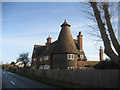
2
The Roundel, Stocks Road, Wittersham, Kent
Image: © Oast House Archive
Taken: 5 Oct 2007
0.03 miles
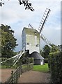
3
Stocks Mill, Wittersham, Kent
The centre post dates back to 1781.
Grade II* listed.
Image: © Oast House Archive
Taken: 16 Mar 2010
0.07 miles
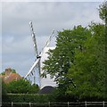
4
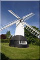
Stocks Windmill, The Stocks near Wittersham
This post-mill is dated 1781 and is sometimes open to the public.
Image: © David Kemp
Taken: 4 May 2014
0.07 miles
5
Stocks Mill, Wittersham
The centre post dates back to 1781.
Grade II* listed.
Image: © Oast House Archive
Taken: 10 May 2015
0.07 miles
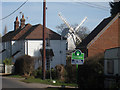
6
Windmill at The Stocks, near Wittersham
Photo taken on a showery evening in early September.
Image: © Stefan Czapski
Taken: 9 Sep 2017
0.07 miles
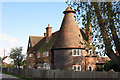
8
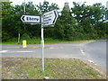
Road sign at The Stocks
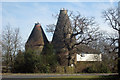
There are some delightful place names in Kent, and Ebony is one of them. The oast house behind is at Stocks Farm - see http://www.geograph.org.uk/photo/338788
Image: © Marathon
Taken: 23 Jun 2014
0.14 miles
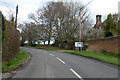
10
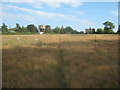
Footpath to The Stocks
This path leads from Acton Lane via Stemps Wood and this horse paddock towards Stocks Road.
In the background is Stocks Water Tower and Stocks Farm Oast House.
Image: © David Anstiss
Taken: 1 Aug 2010
0.15 miles