IMAGES TAKEN NEAR TO
TN30 6ZF
Introduction
This page details the photographs taken nearby to TN30 6ZF by members of the Geograph project.
The Geograph project started in 2005 with the aim of publishing, organising and preserving representative images for every square kilometre of Great Britain, Ireland and the Isle of Man.

There are currently over 7.5m images from over14,400 individuals and you can help contribute to the project by visiting https://www.geograph.org.uk
Image Map
Images are licensed for reuse under creativecommons.org/licenses/by-sa/2.0
Notes
- Clicking on the map will re-center to the selected point.
- The higher the marker number, the further away the image location is from the centre of the postcode.
Image Listing (20 Images Found)
Images are licensed for reuse under creativecommons.org/licenses/by-sa/2.0
Image
Details
Distance
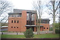
4
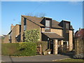
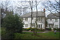
Chapel House
On Turners Avenue, opposite St. Andrews Catholic Church.
Image: © David Anstiss
Taken: 7 Mar 2010
0.20 miles
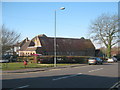
5
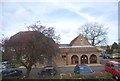
Trinity Baptist Church
On the A28 Ashford Road.
Image: © David Anstiss
Taken: 7 Mar 2010
0.20 miles
10
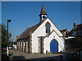
St. Andrews Catholic Church, Tenterden
On the junction of Turners Avenue (in front) and the A28 Ashford Road (unseen, on the right).
Image: © David Anstiss
Taken: 7 Mar 2010
0.21 miles