IMAGES TAKEN NEAR TO
Rolvenden Road, TENTERDEN, TN30 6TY
Introduction
This page details the photographs taken nearby to Rolvenden Road, TN30 6TY by members of the Geograph project.
The Geograph project started in 2005 with the aim of publishing, organising and preserving representative images for every square kilometre of Great Britain, Ireland and the Isle of Man.

There are currently over 7.5m images from over14,400 individuals and you can help contribute to the project by visiting https://www.geograph.org.uk
Image Map
Images are licensed for reuse under creativecommons.org/licenses/by-sa/2.0
Notes
- Clicking on the map will re-center to the selected point.
- The higher the marker number, the further away the image location is from the centre of the postcode.
Image Listing (33 Images Found)
Images are licensed for reuse under creativecommons.org/licenses/by-sa/2.0
Image
Details
Distance
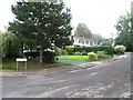
2
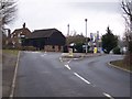
Cranbrook Road meets Rolvenden Road
Cranbrook Road from East End heads towards Tenterden. The A28 Rolvenden Road heads left into Tenterden or right towards Rolvenden. In the background is Tanyard Barn.
Image: © David Anstiss
Taken: 17 Feb 2010
0.02 miles
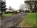
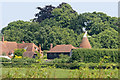
3
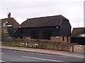
Tanyard Barn
On the A28 Rolvenden Road.
Image: © David Anstiss
Taken: 17 Feb 2010
0.03 miles
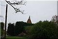
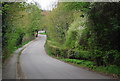
6
Tanyard Oast, Plummer Lane, Tenterden, Kent
Image: © Oast House Archive
Taken: 9 Jun 2008
0.04 miles