IMAGES TAKEN NEAR TO
Ashford Road, TENTERDEN, TN30 6DJ
Introduction
This page details the photographs taken nearby to Ashford Road, TN30 6DJ by members of the Geograph project.
The Geograph project started in 2005 with the aim of publishing, organising and preserving representative images for every square kilometre of Great Britain, Ireland and the Isle of Man.

There are currently over 7.5m images from over14,400 individuals and you can help contribute to the project by visiting https://www.geograph.org.uk
Image Map
Images are licensed for reuse under creativecommons.org/licenses/by-sa/2.0
Notes
- Clicking on the map will re-center to the selected point.
- The higher the marker number, the further away the image location is from the centre of the postcode.
Image Listing (52 Images Found)
Images are licensed for reuse under creativecommons.org/licenses/by-sa/2.0
Image
Details
Distance
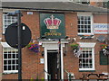
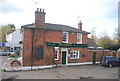
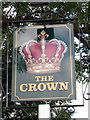
4
The Crown, St Michaels
Freehouse on Grange Road, at junction with Ashford Road.
Image: © Oast House Archive
Taken: 22 Oct 2010
0.00 miles
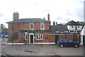
7

St Michaels sign
Erected in 2009 and made by Black Forge Art in Wittersham.
Image: © Oast House Archive
Taken: 22 Oct 2010
0.01 miles
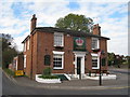
9
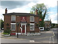
The Crown Public House, St Michaels
On the junction of A28 Ashford Road (on right) and Grange Road (on left).
Image: © David Anstiss
Taken: 3 May 2009
0.03 miles
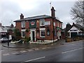
10
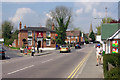
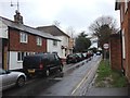
St Michaels
The bustling centre of the village.
Image: © Robin Webster
Taken: 11 Apr 2007
0.03 miles