IMAGES TAKEN NEAR TO
St. Mildreds Close, Church Road, TENTERDEN, TN30 6AZ
Introduction
This page details the photographs taken nearby to St. Mildreds Close, Church Road, TN30 6AZ by members of the Geograph project.
The Geograph project started in 2005 with the aim of publishing, organising and preserving representative images for every square kilometre of Great Britain, Ireland and the Isle of Man.

There are currently over 7.5m images from over14,400 individuals and you can help contribute to the project by visiting https://www.geograph.org.uk
Image Map (Loading...)


Getting Data...Please wait
Leaflet Map data © OpenStreetMap
Images are licensed for reuse under creativecommons.org/licenses/by-sa/2.0
Notes
- Clicking on the map will re-center to the selected point.
- The higher the marker number, the further away the image location is from the centre of the postcode.
Image Listing (670 Images Found)
Images are licensed for reuse under creativecommons.org/licenses/by-sa/2.0
Image
Details
Distance
2
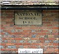
National School 1843
Architectural detail on what is now Tenterden Social Hub Image
Image: © Gerald England
Taken: 26 Apr 2017
0.02 miles
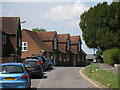
4
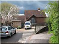
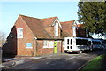
Tenterden Social Hub
The Tenterden National School or Church School was established in Church Road, formerly School Lane, in 1843 in the building that is now used as the Day Centre. The date 1843 can be found on the building Image In the autumn of 1957, the Church Road school building became a separate Infants School (5-7). For the start of the summer term in 1973 the 150 pupils Infant School moved to new purpose built premises in Recreation Ground Road, below the Junior School, and the school buildings in Church Road became the Tenterden Day Centre. https://www.mytenterden.co.uk/directory/20th-century-education-in-tenterden--archive-article-143.aspx Originally it was purely a day centre for the elderly but now it offers services and facilities for other groups in the community and is now known as Tenterden Social Hub https://www.mytenterden.co.uk/directory/tenterden-social-hub-tenterden-day-centre-listing-904.aspx
Image: © Gerald England
Taken: 26 Apr 2017
0.02 miles
9
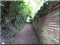
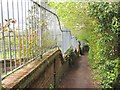
Church Path
Leading from the railway station to the church.
Image: © Gerald England
Taken: 26 Apr 2017
0.04 miles
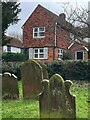
10
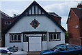
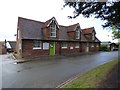
St Mildred's Church Hall, Tenterden (2)
A church hall, with extensions; used as a drill hall during WW1,by the Royal East Kent Mounted Rifles (D Squadron) , 4th Battalion, East Kent Regiment (G Company).
Image: © Peter Barr
Taken: 12 Jun 2014
0.04 miles