IMAGES TAKEN NEAR TO
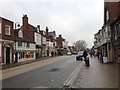
High Street, TENTERDEN, TN30 6AS
Introduction
This page details the photographs taken nearby to High Street, TN30 6AS by members of the Geograph project.
The Geograph project started in 2005 with the aim of publishing, organising and preserving representative images for every square kilometre of Great Britain, Ireland and the Isle of Man.

There are currently over 7.5m images from over14,400 individuals and you can help contribute to the project by visiting https://www.geograph.org.uk
Image Map (Loading...)


Getting Data...Please wait
Leaflet Map data © OpenStreetMap
Images are licensed for reuse under creativecommons.org/licenses/by-sa/2.0
Notes
- Clicking on the map will re-center to the selected point.
- The higher the marker number, the further away the image location is from the centre of the postcode.
Image Listing (674 Images Found)
Images are licensed for reuse under creativecommons.org/licenses/by-sa/2.0
Image
Details
Distance
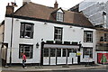
3
Ward & Partners shrouded in scaffolding
Ward & Partners are estate and letting agents and their business is situated at 42 High Street, Tenterden. I assume work was being carried out to the roof.
Image: © John Baker
Taken: 14 Apr 2013
0.01 miles
4
Caf? Rouge, Tenterden
After a fire, spread from the adjacent building, the restaurant is nearing completion of the restoration.
Image: © Oast House Archive
Taken: 21 Apr 2014
0.01 miles
5
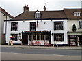
Cafe Rouge, Tenterden
Now a restaurant, Cafe Rouge was once a public house called the Eight Bells.
Image: © Maigheach-gheal
Taken: 18 May 2011
0.01 miles
7
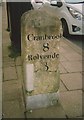
Old Milestone by the A28, High Street, Tenterden
Carved stone post by the A28, in parish of TENTERDEN (ASHFORD District), High Street, opposite Church Road, by No. 55, Estate Agents, in middle of pavement, on South side of road. Tenterden marker erected by the Bethersden turnpike trust in the 18th century.
Inscription reads:-
: Cranbrook / 8 / Rolvende / 3 : : Romney / 14 / RYE / 10 / Ashford / 12 :
Grade II listed.
List Entry Number: 1363175 https://historicengland.org.uk/listing/the-list/list-entry/1363175
Milestone Society National ID: KE_TTAF00.
Image: © C Woodward
Taken: 30 Jul 2010
0.01 miles
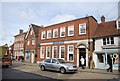
9
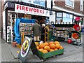
Pumpkins and fireworks for sale, Tenterden High Street
Seasonal requirements at Webb's Ironmongery Store, which has been in business for about 100 years http://www.webbsoftenterden.co.uk/page2.htm . The premises are much older, part of a 15th or 16th century timber framed building http://www.imagesofengland.org.uk/details/default.aspx?id=179724 .
Image: © Rose and Trev Clough
Taken: 17 Oct 2009
0.01 miles