IMAGES TAKEN NEAR TO
Brenzett, ROMNEY MARSH, TN29 9TU
Introduction
This page details the photographs taken nearby to TN29 9TU by members of the Geograph project.
The Geograph project started in 2005 with the aim of publishing, organising and preserving representative images for every square kilometre of Great Britain, Ireland and the Isle of Man.

There are currently over 7.5m images from over14,400 individuals and you can help contribute to the project by visiting https://www.geograph.org.uk
Image Map
Images are licensed for reuse under creativecommons.org/licenses/by-sa/2.0
Notes
- Clicking on the map will re-center to the selected point.
- The higher the marker number, the further away the image location is from the centre of the postcode.
Image Listing (17 Images Found)
Images are licensed for reuse under creativecommons.org/licenses/by-sa/2.0
Image
Details
Distance
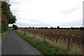
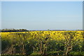
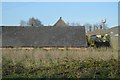
2
Rhee Wall, Callington Court Farm
An idea of the width of the watercourse can be gleaned from this image. The A259 occupies only a small section on the right hand side. The scrub between the road and the barn is also part of the wall evident in the raised bank. Sections of the non-road part of the wall still exist but a fair proportion have now been ploughed out.
Image: © Simon Carey
Taken: 8 Apr 2007
0.06 miles
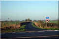
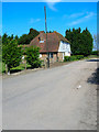
4
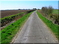
Tillery Lane
A marsh lane built on an embankment between two drains to enable farmers to reach their newly inned fields. Tillery Lane stretches from the Rhee Wall to land south of Brookland. The land here was inned in the twelfth and thirteenth centuries when the population of the marsh was at its zenith.
Image: © Simon Carey
Taken: 8 Apr 2007
0.11 miles
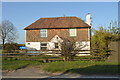
9
Blue House Farm
A farmhouse built on the Rhee Wall utilising the embankment's availability after abandonment and protection being on slightly higher ground.
Image: © Simon Carey
Taken: 8 Apr 2007
0.22 miles