IMAGES TAKEN NEAR TO
Hook Lane, ROMNEY MARSH, TN29 9TB
Introduction
This page details the photographs taken nearby to Hook Lane, TN29 9TB by members of the Geograph project.
The Geograph project started in 2005 with the aim of publishing, organising and preserving representative images for every square kilometre of Great Britain, Ireland and the Isle of Man.

There are currently over 7.5m images from over14,400 individuals and you can help contribute to the project by visiting https://www.geograph.org.uk
Image Map
Images are licensed for reuse under creativecommons.org/licenses/by-sa/2.0
Notes
- Clicking on the map will re-center to the selected point.
- The higher the marker number, the further away the image location is from the centre of the postcode.
Image Listing (6 Images Found)
Images are licensed for reuse under creativecommons.org/licenses/by-sa/2.0
Image
Details
Distance
5
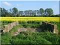
Occupation bridge over the Cheyne Gut Sewer
This lovely old bridge across the delightfully named Cheyne Gut Sewer just leads across to the field of oilseed rape on the other side. The footpath remains on this bank. See http://www.geograph.org.uk/photo/3939748 for another view of the bridge.
Image: © Marathon
Taken: 19 Apr 2014
0.25 miles
6
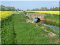
Occupation bridge over Cheyne Gut Sewer
This lovely old bridge across the delightfully named Cheyne Gut Sewer just leads across to the field of oilseed rape on the other side. The footpath remains on this bank.
Image: © Marathon
Taken: 19 Apr 2014
0.25 miles