IMAGES TAKEN NEAR TO
Bowdell Lane, ROMNEY MARSH, TN29 9RW
Introduction
This page details the photographs taken nearby to Bowdell Lane, TN29 9RW by members of the Geograph project.
The Geograph project started in 2005 with the aim of publishing, organising and preserving representative images for every square kilometre of Great Britain, Ireland and the Isle of Man.

There are currently over 7.5m images from over14,400 individuals and you can help contribute to the project by visiting https://www.geograph.org.uk
Image Map
Images are licensed for reuse under creativecommons.org/licenses/by-sa/2.0
Notes
- Clicking on the map will re-center to the selected point.
- The higher the marker number, the further away the image location is from the centre of the postcode.
Image Listing (14 Images Found)
Images are licensed for reuse under creativecommons.org/licenses/by-sa/2.0
Image
Details
Distance
2
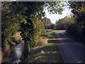
Benzett Sewer & King Street
The drainage channel and road run parallel for a few miles from Poplar Hall to Brenzett.
Image: © Oast House Archive
Taken: 17 Oct 2009
0.05 miles
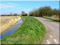
3
Drain alongside King Street
At the junction of Brack lane and King Street
Image: © Julian P Guffogg
Taken: 1 Jul 2011
0.07 miles
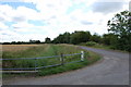
4
King Street
Northern boundary of the Misleham Estate which is never more than a third of a mile wide. Typical marsh lane flanked by drains.
Image: © Simon Carey
Taken: 8 Apr 2007
0.08 miles
5
Access road to Old Hall Farm
This farm road leads from King Street.
Image: © David Anstiss
Taken: 29 Aug 2010
0.09 miles
6
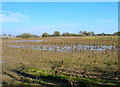
Flooded Cabbage Field
Taken from Bowdell Lane before it crosses the Dungeness railway line.
Image: © Simon Carey
Taken: 8 Apr 2007
0.22 miles
7
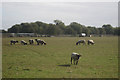
Sheep off Bowdell Lane
Old Dungeness branch line to rear.
Image: © Oast House Archive
Taken: 17 Oct 2009
0.22 miles
8
Dungeness branch line towards Appledore
Viewed from the King Street ungated level crossing, the Dungeness branch is now only used by nuclear flask trains for Dungeness power station.
Image: © Robin Webster
Taken: 29 May 2014
0.23 miles
9
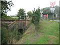
Railway bridge over Brenzett Sewer
This bridge carries the single track line from Dungeness, leading left towards Appledore. The named drain leads along King Street towards Brenzett.
Image: © David Anstiss
Taken: 29 Aug 2010
0.23 miles
10
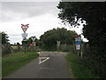
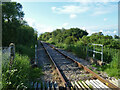
Level crossing on King Street
King Street leads towards Brenzett. It crosses a single track railway heading left to Appledore from Dungeness.
Image: © David Anstiss
Taken: 29 Aug 2010
0.23 miles