IMAGES TAKEN NEAR TO
Old House Lane, ROMNEY MARSH, TN29 9RN
Introduction
This page details the photographs taken nearby to Old House Lane, TN29 9RN by members of the Geograph project.
The Geograph project started in 2005 with the aim of publishing, organising and preserving representative images for every square kilometre of Great Britain, Ireland and the Isle of Man.

There are currently over 7.5m images from over14,400 individuals and you can help contribute to the project by visiting https://www.geograph.org.uk
Image Map (14 Images)


Getting Data...Please wait
Leaflet Map data © OpenStreetMap
Images are licensed for reuse under creativecommons.org/licenses/by-sa/2.0
Notes
- Clicking on the map will re-center to the selected point.
- The higher the marker number, the further away the image location is from the centre of the postcode.
Image Listing (14 Images Found)
Images are licensed for reuse under creativecommons.org/licenses/by-sa/2.0
Image
Details
Distance
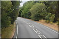
3
Former premises of C M Roger, Straight Lane (A259)
There was a notice on one exterior wall of the premises which read “for sale freehold or to let B1 industrial unit 4000 sq ft offices toilets etc 01797 544392”. When I did a search for the telephone number, I was able to find the name of the company and that it used to deal in pick your own fruit and vegetables. It is marked on the map as being a nursery.
Image: © John Baker
Taken: 17 Aug 2014
0.12 miles
5
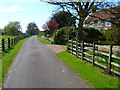
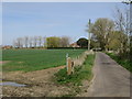
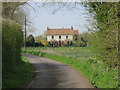
Misleham
The estate of Misleham has existed since Saxon times, however, the current landscape dates back to the 12th century when the estate owners, Christ Church Priory in Canterbury, contracted a tenant to claim back as much land as he could. Misleham Lane is the main track of the estate and its southern boundary. Some of the fields further down have changed little in size since they were inned.
Image: © Simon Carey
Taken: 8 Apr 2007
0.16 miles
8
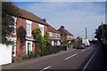
Houses on High Street, Brookland
The nearest house, Pear Tree House is Grade II listed.
Image: © Oast House Archive
Taken: 17 Oct 2009
0.22 miles
10
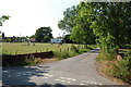
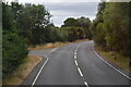
Unnamed Lane off Boarman's Lane, Brookland
Image: © Julian P Guffogg
Taken: 4 Jun 2011
0.24 miles