IMAGES TAKEN NEAR TO
Narrowbush Lane, ROMNEY MARSH, TN29 9FE
Introduction
This page details the photographs taken nearby to Narrowbush Lane, TN29 9FE by members of the Geograph project.
The Geograph project started in 2005 with the aim of publishing, organising and preserving representative images for every square kilometre of Great Britain, Ireland and the Isle of Man.

There are currently over 7.5m images from over14,400 individuals and you can help contribute to the project by visiting https://www.geograph.org.uk
Image Map
Images are licensed for reuse under creativecommons.org/licenses/by-sa/2.0
Notes
- Clicking on the map will re-center to the selected point.
- The higher the marker number, the further away the image location is from the centre of the postcode.
Image Listing (8 Images Found)
Images are licensed for reuse under creativecommons.org/licenses/by-sa/2.0
Image
Details
Distance
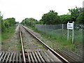
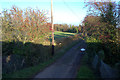
2
Narrowbush Lane
Looking north-eastwards from the level crossing
Image: © Robert Eva
Taken: 17 Nov 2018
0.06 miles
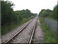
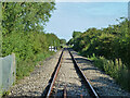
3
Railway line to Dungeness
I've never seen a train on it!
Image: © Julian P Guffogg
Taken: 26 Aug 2012
0.10 miles
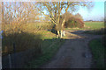
4
Dungeness Branch Line
Viewed from Tillery Lane crossing.
Image: © Oast House Archive
Taken: 24 Jul 2010
0.12 miles
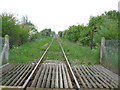
5

Tillery Level Crossing
No barriers or gates due to the almost non existent trains.
Tillery Lane crosses here.
Image: © Julian P Guffogg
Taken: 26 Aug 2012
0.14 miles
6
Tillery Lane
Taken from a train passing over the level crossing.
Image: © Robert Eva
Taken: 17 Nov 2018
0.15 miles
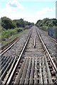
7
Railway track across Romney Marsh viewed from Tillery Crossing
Image: © Rachel Hunt
Taken: 4 May 2007
0.21 miles
8
Dungeness branch line towards Dungeness
Now only used by nuclear flask trains for Dungeness power station. A view from Boarmans Crossing on Tickner's Lane which has no gates. The 5 mph limit and whistle sign are for the next similar crossing at Tillery Lane.
Image: © Robin Webster
Taken: 29 May 2014
0.24 miles