IMAGES TAKEN NEAR TO
The Derings, ROMNEY MARSH, TN29 9BG
Introduction
This page details the photographs taken nearby to The Derings, TN29 9BG by members of the Geograph project.
The Geograph project started in 2005 with the aim of publishing, organising and preserving representative images for every square kilometre of Great Britain, Ireland and the Isle of Man.

There are currently over 7.5m images from over14,400 individuals and you can help contribute to the project by visiting https://www.geograph.org.uk
Image Map (Loading...)


Getting Data...Please wait
Leaflet Map data © OpenStreetMap
Images are licensed for reuse under creativecommons.org/licenses/by-sa/2.0
Notes
- Clicking on the map will re-center to the selected point.
- The higher the marker number, the further away the image location is from the centre of the postcode.
Image Listing (82 Images Found)
Images are licensed for reuse under creativecommons.org/licenses/by-sa/2.0
Image
Details
Distance
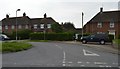
5
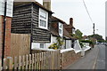
Terraced Housing on High Street
The road joins to Tourney Road just around the bend.
Image: © Oast House Archive
Taken: 23 May 2010
0.06 miles
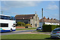
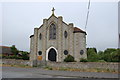
6
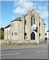
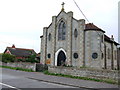
St Martin of Tours, High Street
The former Roman Catholic church is up for sale through the chartered surveyors Stanley Hicks http://stanleyhicks.co.uk/
This was Image before it was deconsecrated.
Image: © John Baker
Taken: 28 Oct 2018
0.07 miles
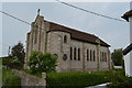
7
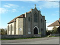
Lydd Catholic Church, Lydd, Romney Marsh, Kent
Image: © Paul Russon
Taken: 19 Apr 2005
0.07 miles