IMAGES TAKEN NEAR TO
Cedar Crescent, ROMNEY MARSH, TN29 0XJ
Introduction
This page details the photographs taken nearby to Cedar Crescent, TN29 0XJ by members of the Geograph project.
The Geograph project started in 2005 with the aim of publishing, organising and preserving representative images for every square kilometre of Great Britain, Ireland and the Isle of Man.

There are currently over 7.5m images from over14,400 individuals and you can help contribute to the project by visiting https://www.geograph.org.uk
Image Map
Images are licensed for reuse under creativecommons.org/licenses/by-sa/2.0
Notes
- Clicking on the map will re-center to the selected point.
- The higher the marker number, the further away the image location is from the centre of the postcode.
Image Listing (80 Images Found)
Images are licensed for reuse under creativecommons.org/licenses/by-sa/2.0
Image
Details
Distance
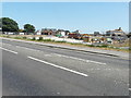
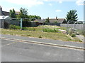
2
Holiday park, Dymchurch Road, St Mary?s Bay
Planning permission was approved, with conditions, by Folkestone and Hythe District Council under application number Y16/0534/SH for “change of use of the land to a holiday park for general holiday use, together with the partial demolition of existing holiday accommodation and erection of new holiday accommodation buildings and replacement swimming pool, formation of camping area, together with associated access, parking and infrastructure”.
This was the Image in July 2018 before the fence was erected.
Image: © John Baker
Taken: 27 Jan 2019
0.14 miles
3
Holiday park, Dymchurch Road, St Mary?s Bay
Planning permission was approved, with conditions, by Folkestone and Hythe District Council under application number Y16/0534/SH for “change of use of the land to a holiday park for general holiday use, together with the partial demolition of existing holiday accommodation and erection of new holiday accommodation buildings and replacement swimming pool, formation of camping area, together with associated access, parking and infrastructure”.
These were the former buildings of the Image
Image: © John Baker
Taken: 8 Jul 2018
0.16 miles
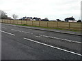
4
Rugby Clubs Campsite, Dymchurch Road, St Mary?s Bay
Planning permission has been approved, with conditions, by Folkestone and Hythe District Council under application number Y12/0585/SH for the “demolition of existing buildings and structures and construction of a sleeping accommodation block, entrance pavilion, swimming pool building, games hall and gallery and layout of sports pitches and car park with associated landscaping and boundary treatment”.
Image: © John Baker
Taken: 16 Aug 2015
0.16 miles
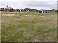
5
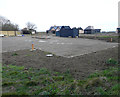
Site for development, Newlands
Planning permission has been approved, with conditions, by Folkestone and Hythe District Council under application number Y17/0150/SH for the “erection of a pair of semi-detached houses with off-street parking for both properties and the existing property number 33, Newlands”.
The site is now occupied by Image
Image: © John Baker
Taken: 8 Jul 2018
0.17 miles
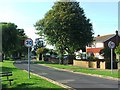
6
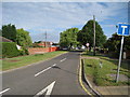
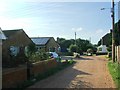
Taylors Lane
Cul-de-sac off Dymchurch Road.
Image: © Oast House Archive
Taken: 18 Jul 2010
0.17 miles
7

32a & 32b, Newlands
In July 2018, this location was a Image
Image: © John Baker
Taken: 6 Sep 2020
0.17 miles
8
Holiday park from the England Coast Path
This is the Image from Dymchurch Road.
Image: © John Baker
Taken: 11 Aug 2019
0.17 miles
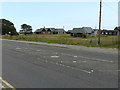
10
Holiday park, Dymchurch Road, St Mary?s Bay
Planning permission was approved, with conditions, by Folkestone and Hythe District Council under application number Y16/0534/SH for “change of use of the land to a holiday park for general holiday use, together with the partial demolition of existing holiday accommodation and erection of new holiday accommodation buildings and replacement swimming pool, formation of camping area, together with associated access, parking and infrastructure”.
This image of the buildings was taken from a public footpath, which runs down one side of the development.
Image: © John Baker
Taken: 27 Jan 2019
0.18 miles