IMAGES TAKEN NEAR TO
Denham Close, ROMNEY MARSH, TN29 0TU
Introduction
This page details the photographs taken nearby to Denham Close, TN29 0TU by members of the Geograph project.
The Geograph project started in 2005 with the aim of publishing, organising and preserving representative images for every square kilometre of Great Britain, Ireland and the Isle of Man.

There are currently over 7.5m images from over14,400 individuals and you can help contribute to the project by visiting https://www.geograph.org.uk
Image Map (Loading...)


Getting Data...Please wait
Leaflet Map data © OpenStreetMap
Images are licensed for reuse under creativecommons.org/licenses/by-sa/2.0
Notes
- Clicking on the map will re-center to the selected point.
- The higher the marker number, the further away the image location is from the centre of the postcode.
Image Listing (29 Images Found)
Images are licensed for reuse under creativecommons.org/licenses/by-sa/2.0
Image
Details
Distance


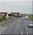
6
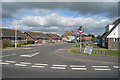
Bungalows on Crimond Avenue
A strange name for a short dead-end - perhaps the developers had expansionist plans.
Image: © Robin Webster
Taken: 28 Oct 2014
0.16 miles
8
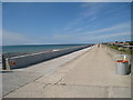
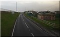
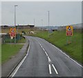
Sea Defences, Hythe
Large embankment with road and path along the top.
Image: © Oast House Archive
Taken: 11 Jul 2010
0.19 miles
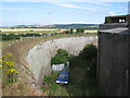
10
Dymchurch - 2008
Romney, Hythe & Dymchurch Railway, Dymchurch Redoubt and Hythe Range visible in the distance.
Image: © Helmut Zozmann
Taken: 5 Jul 2008
0.21 miles