IMAGES TAKEN NEAR TO
Kingsland Hollow, ROMNEY MARSH, TN29 0RE
Introduction
This page details the photographs taken nearby to Kingsland Hollow, TN29 0RE by members of the Geograph project.
The Geograph project started in 2005 with the aim of publishing, organising and preserving representative images for every square kilometre of Great Britain, Ireland and the Isle of Man.

There are currently over 7.5m images from over14,400 individuals and you can help contribute to the project by visiting https://www.geograph.org.uk
Image Map
Images are licensed for reuse under creativecommons.org/licenses/by-sa/2.0
Notes
- Clicking on the map will re-center to the selected point.
- The higher the marker number, the further away the image location is from the centre of the postcode.
Image Listing (53 Images Found)
Images are licensed for reuse under creativecommons.org/licenses/by-sa/2.0
Image
Details
Distance
2
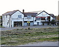
Derelict Shops
Derelict shops at St Mary's Bay.
Image: © Stuart Vickers
Taken: 30 May 1998
0.03 miles
4
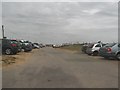
St Mary's Bay Sands car park
On the A259 Dymchurch Road. Gives access to the sandy beach.
Image: © David Anstiss
Taken: 3 Jul 2010
0.04 miles