IMAGES TAKEN NEAR TO
Eastbridge Road, ROMNEY MARSH, TN29 0PG
Introduction
This page details the photographs taken nearby to Eastbridge Road, TN29 0PG by members of the Geograph project.
The Geograph project started in 2005 with the aim of publishing, organising and preserving representative images for every square kilometre of Great Britain, Ireland and the Isle of Man.

There are currently over 7.5m images from over14,400 individuals and you can help contribute to the project by visiting https://www.geograph.org.uk
Image Map (Loading...)


Getting Data...Please wait
Leaflet Map data © OpenStreetMap
Images are licensed for reuse under creativecommons.org/licenses/by-sa/2.0
Notes
- Clicking on the map will re-center to the selected point.
- The higher the marker number, the further away the image location is from the centre of the postcode.
Image Listing (11 Images Found)
Images are licensed for reuse under creativecommons.org/licenses/by-sa/2.0
Image
Details
Distance
1
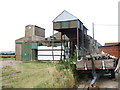
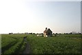
Farm buildings, Eastbridge Road, near Dymchurch
Image: © Chris Whippet
Taken: 20 Jul 2009
0.02 miles
2
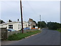
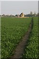
Eastbridge Road, heading towards Dymchurch
Image: © Chris Whippet
Taken: 20 Jul 2009
0.08 miles
3
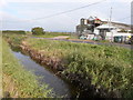
Sutton Farm, Eastbridge Road
Seen from the other side of Marshland Sewer.
Image: © John Baker
Taken: 18 Oct 2015
0.09 miles
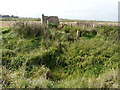
5
Looker's Hut
One of the very few remaining Looker's Huts, this one is in reasonable condition.
Image: © Mark Duncan
Taken: 14 Apr 2007
0.12 miles
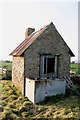
7
Remains of a Looker?s Hut
Lookers were employed to look after a farmer’s stock and these huts provided basic accommodation, which was used at lambing time. The huts had an open fire, on the hearth, over which a kettle or cauldron was hung, on a pot-hook, to provide meals for the shepherd or for heating milk for weak and sickly lambs. The huts would have also had crude sleeping arrangements – probably nothing more than a few boards on which there might have been sacks, stuffed with straw, to act as a mattress. Sanitary arrangements would have been non-existent and any water for cooking would have been obtained from the nearest dyke. His family would come at weekends to spend a day with him, bringing his supplies for the whole week.
Unfortunately Mark Duncan’s Image taken 8 years ago, now appears to be almost unrecognisable. Nigel P Crick has written an illustrated book called The Lookers’ Huts ISBN 978 1 84624 426 1, which gives the grid reference locations of 16 huts, that can be found on Romney Marsh, as well as a link to his photography business http://www.gallerytwentyone.co.uk This is one of the huts he mentions in the book.
Image: © John Baker
Taken: 18 Oct 2015
0.12 miles
9
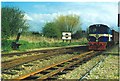
Dymchurch.
South-bound train approaching on R.H.& D.R.
Image: © Ron Hann
Taken: Unknown
0.24 miles
10
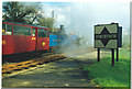
Dymchurch.
After the dust and smoke settle....
Image: © Ron Hann
Taken: Unknown
0.24 miles