IMAGES TAKEN NEAR TO
Lower Sands, ROMNEY MARSH, TN29 0NE
Introduction
This page details the photographs taken nearby to Lower Sands, TN29 0NE by members of the Geograph project.
The Geograph project started in 2005 with the aim of publishing, organising and preserving representative images for every square kilometre of Great Britain, Ireland and the Isle of Man.

There are currently over 7.5m images from over14,400 individuals and you can help contribute to the project by visiting https://www.geograph.org.uk
Image Map (Loading...)


Getting Data...Please wait
Leaflet Map data © OpenStreetMap
Images are licensed for reuse under creativecommons.org/licenses/by-sa/2.0
Notes
- Clicking on the map will re-center to the selected point.
- The higher the marker number, the further away the image location is from the centre of the postcode.
Image Listing (61 Images Found)
Images are licensed for reuse under creativecommons.org/licenses/by-sa/2.0
Image
Details
Distance
7
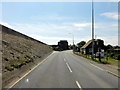
Dymchurch, Hythe Road
Dymchurch, Hythe Road (A259), Martello Tower No. 23. Martello Tower No. 23 was built to protect the Willop Sluice in Hythe Road, paired with Martello Tower No. 22, which was destroyed to make way for road widening. This tower has been restored and is used as a residence.
Image: © Helmut Zozmann
Taken: 15 Jul 2011
0.13 miles
8
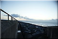
View of the rock armour on Dymchurch beach #2
Looking south-southeast.
Image: © Robert Lamb
Taken: 4 Sep 2016
0.14 miles