IMAGES TAKEN NEAR TO
Thorndike, ROMNEY MARSH, TN29 0JP
Introduction
This page details the photographs taken nearby to Thorndike, TN29 0JP by members of the Geograph project.
The Geograph project started in 2005 with the aim of publishing, organising and preserving representative images for every square kilometre of Great Britain, Ireland and the Isle of Man.

There are currently over 7.5m images from over14,400 individuals and you can help contribute to the project by visiting https://www.geograph.org.uk
Image Map
Images are licensed for reuse under creativecommons.org/licenses/by-sa/2.0
Notes
- Clicking on the map will re-center to the selected point.
- The higher the marker number, the further away the image location is from the centre of the postcode.
Image Listing (84 Images Found)
Images are licensed for reuse under creativecommons.org/licenses/by-sa/2.0
Image
Details
Distance
1
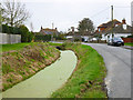
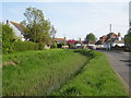
Drain by Thorndike Road, Burmarsh
Not the sort of ditch to drive into.
Image: © Robin Webster
Taken: 28 Oct 2014
0.01 miles
2
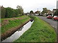
Drainage Channel
Full of reeds and running along side Thorndike Road.
Image: © Oast House Archive
Taken: 14 May 2010
0.02 miles
3
Drainage Channel in Burmarsh
Beside Thorndike Road.
Compare with Image with channel not clear !
Image: © David Anstiss
Taken: 17 Oct 2010
0.02 miles
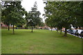
5
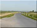
A distant view of Burmarsh
The road is Burmarsh Road.
Image: © John Baker
Taken: 18 Apr 2010
0.04 miles
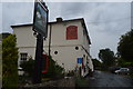
6
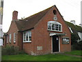
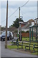
Burmarsh Church Room
This brick building is opposite Image
It was a former library for the small village. Now a church hall, used for polling days.
Image: © David Anstiss
Taken: 17 Oct 2010
0.05 miles