IMAGES TAKEN NEAR TO
Church Road, ROMNEY MARSH, TN29 0JD
Introduction
This page details the photographs taken nearby to Church Road, TN29 0JD by members of the Geograph project.
The Geograph project started in 2005 with the aim of publishing, organising and preserving representative images for every square kilometre of Great Britain, Ireland and the Isle of Man.

There are currently over 7.5m images from over14,400 individuals and you can help contribute to the project by visiting https://www.geograph.org.uk
Image Map
Images are licensed for reuse under creativecommons.org/licenses/by-sa/2.0
Notes
- Clicking on the map will re-center to the selected point.
- The higher the marker number, the further away the image location is from the centre of the postcode.
Image Listing (21 Images Found)
Images are licensed for reuse under creativecommons.org/licenses/by-sa/2.0
Image
Details
Distance
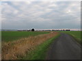
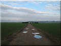
2
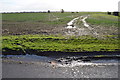
Waterlogged field off Church Road
The road does indeed go all the way to Burmarsh Church Image
Image: © Julian P Guffogg
Taken: 30 Dec 2012
0.04 miles
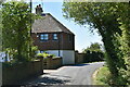
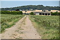
6
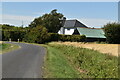
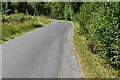
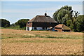
Church Road
This road leads from East Bridge Road towards Burmarsh.
In the far background is Tame Lane Cottage and farm barns.
Image: © David Anstiss
Taken: 21 Nov 2010
0.09 miles
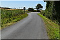
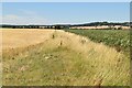
10
Track to barns in the Romney Marshes
This track leads from Church Road, through the barns towards Lower Wall Road.
Image: © David Anstiss
Taken: 21 Nov 2010
0.18 miles