IMAGES TAKEN NEAR TO
Newlands, ROMNEY MARSH, TN29 0EX
Introduction
This page details the photographs taken nearby to Newlands, TN29 0EX by members of the Geograph project.
The Geograph project started in 2005 with the aim of publishing, organising and preserving representative images for every square kilometre of Great Britain, Ireland and the Isle of Man.

There are currently over 7.5m images from over14,400 individuals and you can help contribute to the project by visiting https://www.geograph.org.uk
Image Map (Loading...)


Getting Data...Please wait
Leaflet Map data © OpenStreetMap
Images are licensed for reuse under creativecommons.org/licenses/by-sa/2.0
Notes
- Clicking on the map will re-center to the selected point.
- The higher the marker number, the further away the image location is from the centre of the postcode.
Image Listing (33 Images Found)
Images are licensed for reuse under creativecommons.org/licenses/by-sa/2.0
Image
Details
Distance
1

32a & 32b, Newlands
In July 2018, this location was a Image
Image: © John Baker
Taken: 6 Sep 2020
0.04 miles
2
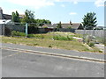
Site for development, Newlands
Planning permission has been approved, with conditions, by Folkestone and Hythe District Council under application number Y17/0150/SH for the “erection of a pair of semi-detached houses with off-street parking for both properties and the existing property number 33, Newlands”.
The site is now occupied by Image
Image: © John Baker
Taken: 8 Jul 2018
0.05 miles
4
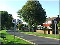
Taylors Lane
Cul-de-sac off Dymchurch Road.
Image: © Oast House Archive
Taken: 18 Jul 2010
0.07 miles
5
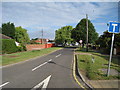
New Sewer, St. Mary's Bay
East of the Romney, Hythe and Dymchurch Railway bridge.
Image: © Robin Webster
Taken: 13 Jul 2013
0.10 miles
6
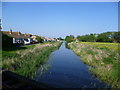
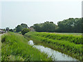
New Sewer from the Romney, Hythe & Dymchurch Railway
It is always interesting when travelling on the Romney, Hythe & Dymchurch Railway to pass over the many dykes which criss-cross Romney Marsh. This is the New Sewer, a drainage channel which reaches the sea at St Mary's Bay, looking towards the sea. The bungalows on the left are on Grassmere, which is part of St Mary's Bay.
Image: © Marathon
Taken: 26 May 2012
0.10 miles
7
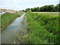
New Sewer (Drain), east of the railway
Alongside bungalows in Grasmere, St Mary's Bay.
Image: © Christine Johnstone
Taken: 12 Jul 2013
0.12 miles
8
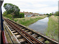
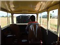
Crossing New Sewer on Collins Bridge
View east from a Romney, Hythe & Dymchurch Railway train near St Mary's Bay.
Image: © Gareth James
Taken: 12 May 2018
0.13 miles
9
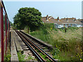
Bridge over New Sewer
The Romney, Hythe and Dymchurch Railway crosses on the outskirts of St. Mary's Bay.
Image: © Robin Webster
Taken: 13 Jul 2013
0.13 miles
10
St Mary's Bay - 2007
St Mary's Bay, Romney, Hythe & Dymchurch Railway, licensed RH&DR Observation Car No. 501 'Gladys' running behind the engine.
Image: © Helmut Zozmann
Taken: 21 Jul 2007
0.14 miles