IMAGES TAKEN NEAR TO
Snargate, ROMNEY MARSH, TN29 0EW
Introduction
This page details the photographs taken nearby to TN29 0EW by members of the Geograph project.
The Geograph project started in 2005 with the aim of publishing, organising and preserving representative images for every square kilometre of Great Britain, Ireland and the Isle of Man.

There are currently over 7.5m images from over14,400 individuals and you can help contribute to the project by visiting https://www.geograph.org.uk
Image Map (Loading...)


Getting Data...Please wait
Leaflet Map data © OpenStreetMap
Images are licensed for reuse under creativecommons.org/licenses/by-sa/2.0
Notes
- Clicking on the map will re-center to the selected point.
- The higher the marker number, the further away the image location is from the centre of the postcode.
Image Listing (191 Images Found)
Images are licensed for reuse under creativecommons.org/licenses/by-sa/2.0
Image
Details
Distance

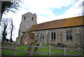
5
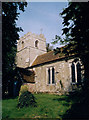
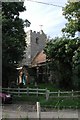
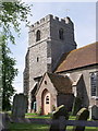
St Dunstan, Snargate
Erected in the 15th century.
Image: © Michael FORD
Taken: Unknown
0.02 miles
6
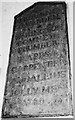
Sign in St. Dunstan's Church, Snargate
Commemorating those who paid for the work and those wot done it. Dated 1780.
Image: © tristan forward
Taken: 12 Jul 2009
0.03 miles
8
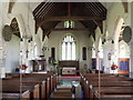
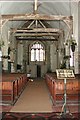
Interior of St. Dunstan's, Snargate, Kent
Image: © nick macneill
Taken: 14 May 2010
0.03 miles
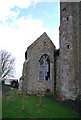
10
Wonky footpath signpost near St Dunstan Church.
Image: © N Chadwick
Taken: 6 Mar 2010
0.03 miles