IMAGES TAKEN NEAR TO
Brenzett, ROMNEY MARSH, TN29 0EG
Introduction
This page details the photographs taken nearby to TN29 0EG by members of the Geograph project.
The Geograph project started in 2005 with the aim of publishing, organising and preserving representative images for every square kilometre of Great Britain, Ireland and the Isle of Man.

There are currently over 7.5m images from over14,400 individuals and you can help contribute to the project by visiting https://www.geograph.org.uk
Image Map (Loading...)


Getting Data...Please wait
Leaflet Map data © OpenStreetMap
Images are licensed for reuse under creativecommons.org/licenses/by-sa/2.0
Notes
- Clicking on the map will re-center to the selected point.
- The higher the marker number, the further away the image location is from the centre of the postcode.
Image Listing (4 Images Found)
Images are licensed for reuse under creativecommons.org/licenses/by-sa/2.0
Image
Details
Distance
1

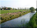
Sheepfold near Codhall
Codhall can be seen in the background, the sheep pen to the left of the sewer.
Image: © Simon Carey
Taken: 8 Apr 2007
0.03 miles
2
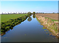
Abbatridge Sewer
The sewer runs from Brenzett Green to Snargate. The footbridge carrying the footpath from Snargate to Codhall is between the two trees.
Image: © Simon Carey
Taken: 8 Apr 2007
0.07 miles
3
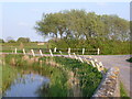
The Abbatridge Sewer
The drainage ditch is the Abbatridge Sewer. Codhall Farm on Church Lane, Brenzett is on the left and in between are the Romney sheep. One of the traits of the Romney sheep is to spread out when they are grazing. This is well seen here.
Image: © Marathon
Taken: 19 Apr 2014
0.07 miles
4
Romney Marsh scene near Brenzett
Church Lane is the road meeting the junction on the right. This comes from Brenzett and Brenzett Church. The road to the left leads to Brenzett Green. The drainage ditch is the Abbatridge Sewer.
Image: © Marathon
Taken: 19 Apr 2014
0.09 miles