IMAGES TAKEN NEAR TO
Newchurch, ROMNEY MARSH, TN29 0DH
Introduction
This page details the photographs taken nearby to TN29 0DH by members of the Geograph project.
The Geograph project started in 2005 with the aim of publishing, organising and preserving representative images for every square kilometre of Great Britain, Ireland and the Isle of Man.

There are currently over 7.5m images from over14,400 individuals and you can help contribute to the project by visiting https://www.geograph.org.uk
Image Map
Images are licensed for reuse under creativecommons.org/licenses/by-sa/2.0
Notes
- Clicking on the map will re-center to the selected point.
- The higher the marker number, the further away the image location is from the centre of the postcode.
Image Listing (40 Images Found)
Images are licensed for reuse under creativecommons.org/licenses/by-sa/2.0
Image
Details
Distance
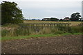
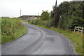
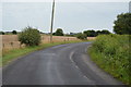
3
Marten Farm
On a lane between New Romney and Newchurch.
Image: © David Anstiss
Taken: 21 Nov 2010
0.02 miles
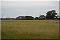
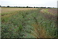
5
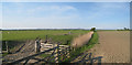
Drainage Channel
Near Marten Farm. A footpath to Chapel Cottage Farm begins here.
Image: © Oast House Archive
Taken: 14 May 2010
0.08 miles

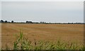
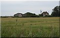
9
Clobsden Sewer
Image: © N Chadwick
Taken: 18 Aug 2015
0.11 miles