IMAGES TAKEN NEAR TO
Chittendens Lane, ROMNEY MARSH, TN29 0DF
Introduction
This page details the photographs taken nearby to Chittendens Lane, TN29 0DF by members of the Geograph project.
The Geograph project started in 2005 with the aim of publishing, organising and preserving representative images for every square kilometre of Great Britain, Ireland and the Isle of Man.

There are currently over 7.5m images from over14,400 individuals and you can help contribute to the project by visiting https://www.geograph.org.uk
Image Map (Loading...)


Getting Data...Please wait
Leaflet Map data © OpenStreetMap
Images are licensed for reuse under creativecommons.org/licenses/by-sa/2.0
Notes
- Clicking on the map will re-center to the selected point.
- The higher the marker number, the further away the image location is from the centre of the postcode.
Image Listing (8 Images Found)
Images are licensed for reuse under creativecommons.org/licenses/by-sa/2.0
Image
Details
Distance
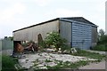
1
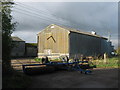
Unusual farm barrier
This roller has been placed at the entrance to Goose Farm on Chittenden's Lane.
Image: © David Anstiss
Taken: 7 Nov 2010
0.00 miles
5
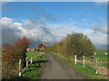
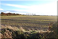
Road Bridge on Chittenden's Lane
This lane leads from Tonbridge Farm towards Norwood Lane.
It leads over a drainage channel in the Romnay Marshes.
Goose Farm is in the background.
Image: © David Anstiss
Taken: 7 Nov 2010
0.10 miles
6
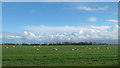
Field near Honeychild Manor
As seen from Chittenden's Lane.
Image: © David Anstiss
Taken: 7 Nov 2010
0.16 miles
7
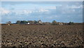
View of St. Mary in the Marsh
As seen from Chittenden's Lane.
Image: © David Anstiss
Taken: 7 Nov 2010
0.25 miles